
Connecting Sheffield: Burngreave

Burngreave is a busy neighbourhood where lots of people walk or use buses for everyday journeys. We aim to improve roads and streets in Burngreave so that everyone wants to use and enjoy them. Crucially, we want residents to feel happier, healthier, and proud of where they live.
We want people in Burngreave to have greater choice in how they get around. By improving roads and streets, we aim to make local journeys easier, safer and more attractive for people - whether they’re walking to the bus stop, wheeling to the shops, or cycling to work.
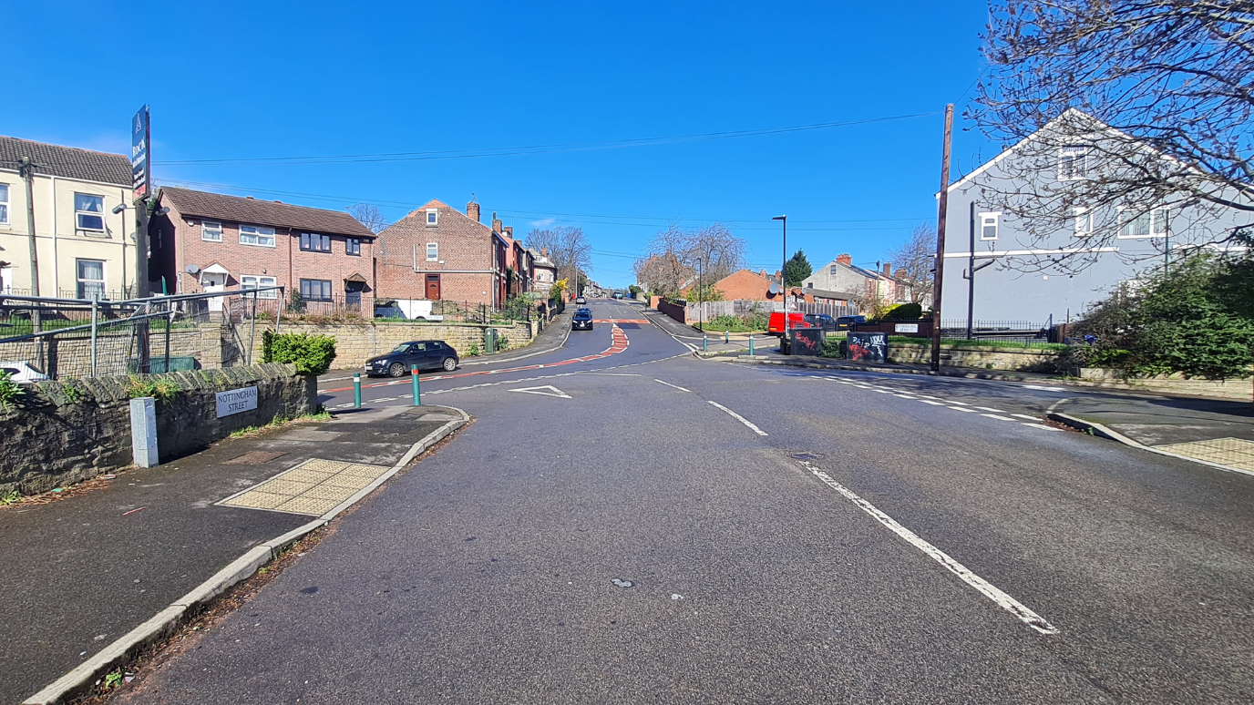 Image of the Burngreave area
Our proposals are focused on Rock Street and Nottingham Street. Improvements will give priority to people crossing side roads, encouraging drivers to slow down and give way at junctions. This reflects recent changes to the Highway Code. We also plan to:
- make it easier and safer to catch a bus
- stop problem parking
- improve bus and car journeys on Rock Street and Nottingham Street
- make roads safer for everyone, regardless of how they get around
These changes will complement the School Streets at Astrea Academy and Pye Bank Primary School, making it safer and easier for children and families to walk and wheel to school.
Public consultation in February to April 2026
We consulted on our planned improvements from February to April 2026. We received 182 responses during the public consultation through:
- online and paper surveys
- door to door surveys
- feedback by email, phone and letter
We spoke with local people in person. We received feedback from 25 people who attended two public events. We also met with 11 parents and some staff at Pye Bank Primary School, which is near to the proposed improvements on Rock Street and Nottingham Street.
We have now made further changes to our plans. These are based on:
- feedback from people during the consultation process
- comments from the project funders - Active Travel England and the South Yorkshire Mayoral Combined Authority
- information from parking surveys carried out on Rock Street, Nottingham Street and nearby roads.
- surveys to identify underground pipes, cables and other services
- reviews and advice from Sheffield City Council’s design team and delivery partners
You can find more detailed information about the consultation process and the feedback we received in the full Public Consultation Report.
Traffic Regulation Order (TRO) and statutory consultation period - 24 September to 22 October 2026
We have included information about the planned improvements below, describing changes that we have made following public feedback. Some of these improvements need a Traffic Regulation Order (TRO), which is a legal document required for the Council to be able to make certain changes to how a road is used.
This process means we need consult with people, enabling them to provide their feedback on the changes that need a TRO. We will make people aware of the TRO consultation by placing notices on-street, advertising in the local newspaper, and by writing to nearby properties. Paper copies of the TRO are available on request. If you need information in a different format, please contact us using our usual communication channels available at the end of this webpage.
Please be aware that we will not be consulting again on the wider proposals we consulted on earlier in the year. We have highlighted below which improvements we are asking for feedback on through the TRO process.
The proposed changes following the public consultation
The maps below show the changes we have made to the project, following feedback we received during the public consultation. Some of the proposed changes in this project are subject to a Traffic Regulation Order (TRO).
To view and comment on the TRO proposals visit our Appyway portal.
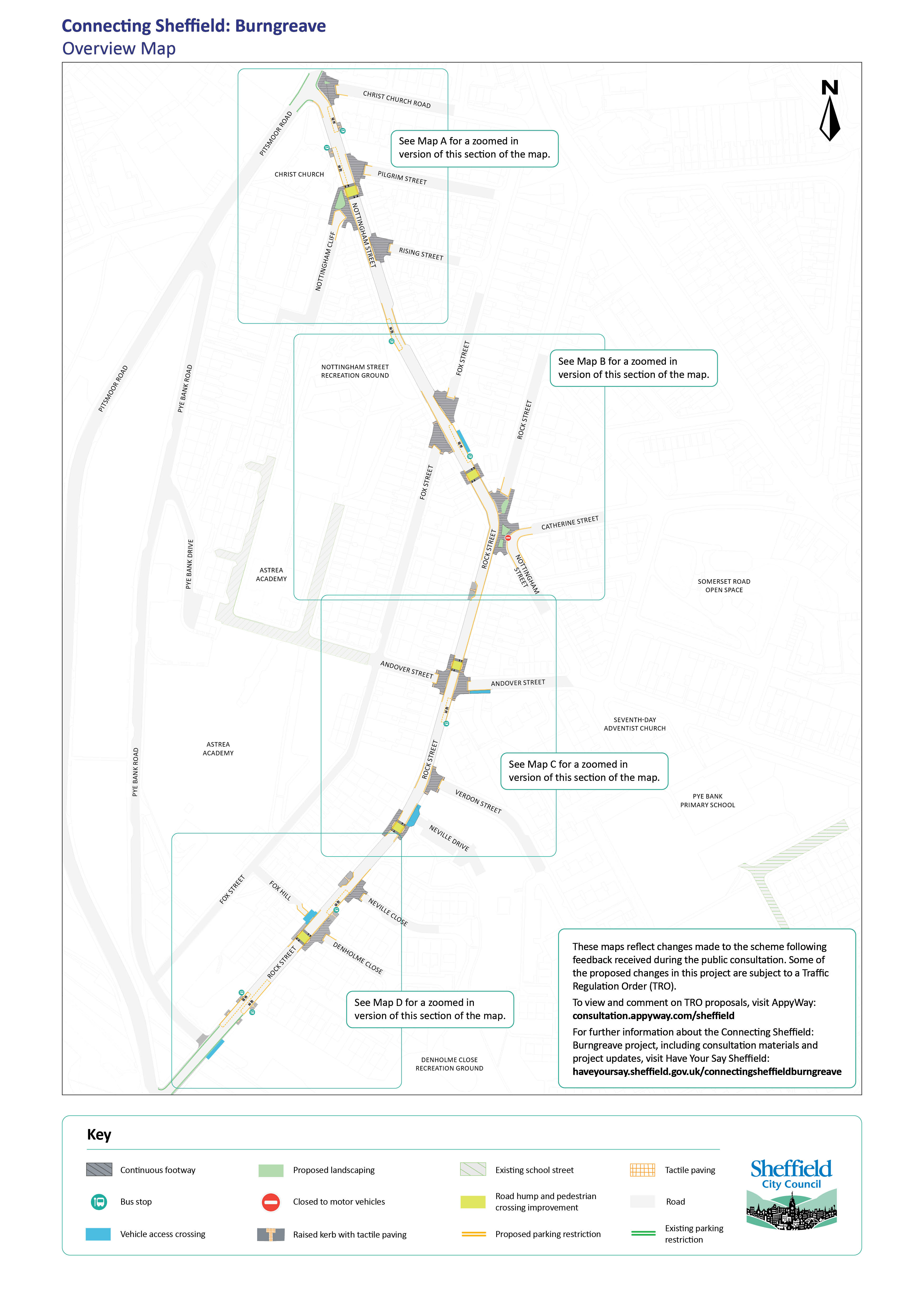 Overview map of Burngreave between Nottingham Street and Rock Street
The overview map shows the Burngreave area between Nottingham Street and Rock Street:
- The map also shows several junctions on this stretch of road
- The map has been separated into four sections along the stretch of road. You can view each of the sections in detail using the pdf links for Maps A, B, C and D below
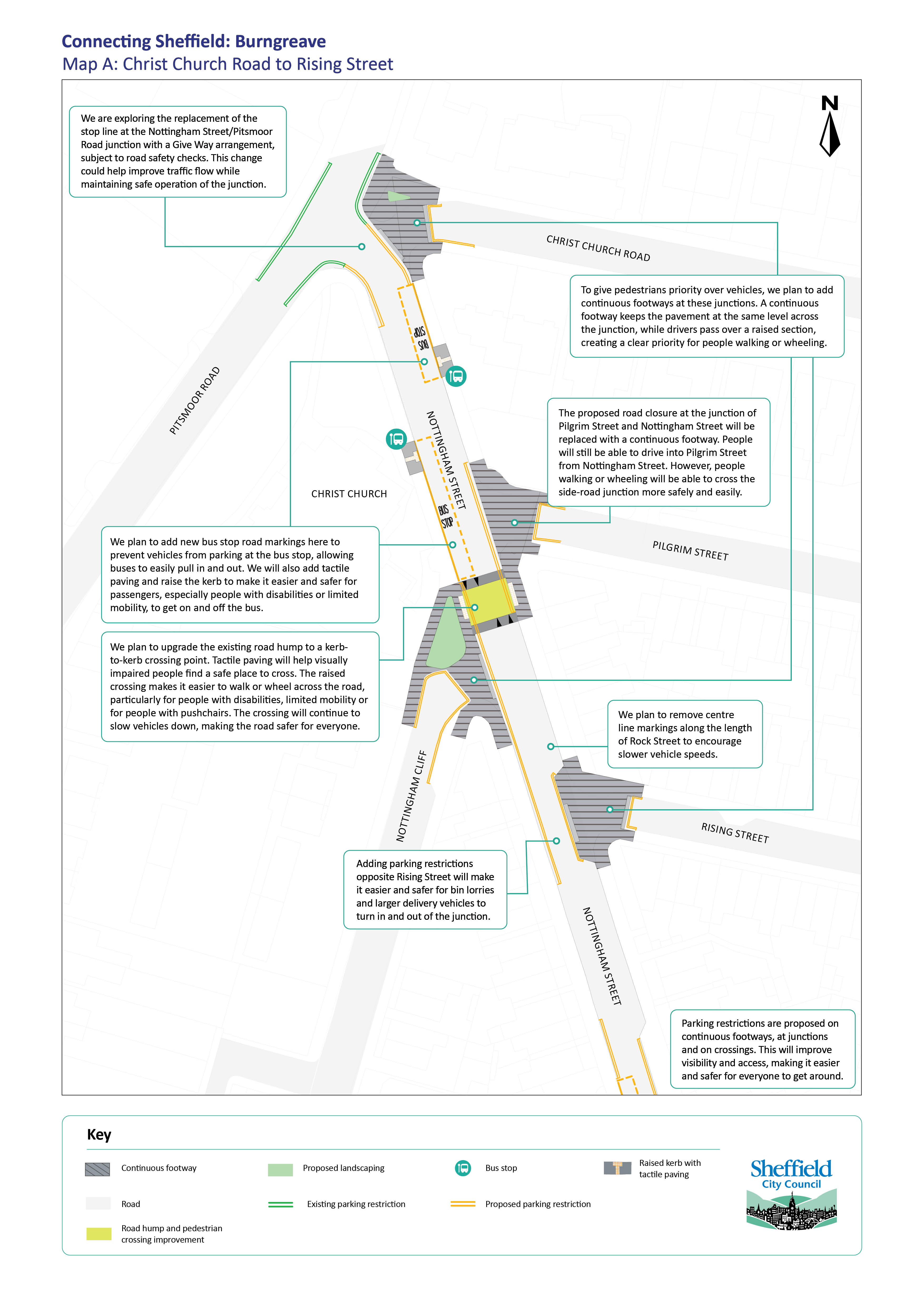 Map A showing proposed improvements between Christ Church Road to Rising Street
Map A shows proposals at the top of Nottingham Street between Christ Church Road and Rising Street including:
- Continuous footways at side-road junctions to create priority for people walking or wheeling
- Continuous footway at the junction of Pilgrim Street and Nottingham Street
- New bus stop clearway markings, raised kerbs and tactile paving at bus stops
- Upgrading the road hump with a kerb-to-kerb crossing point between Pilgrim Street and Nottingham Cliff
- Parking restrictions on junctions, continuous footways, crossings and where the road narrows
View this map as a PDF so that you can zoom in for more detail.
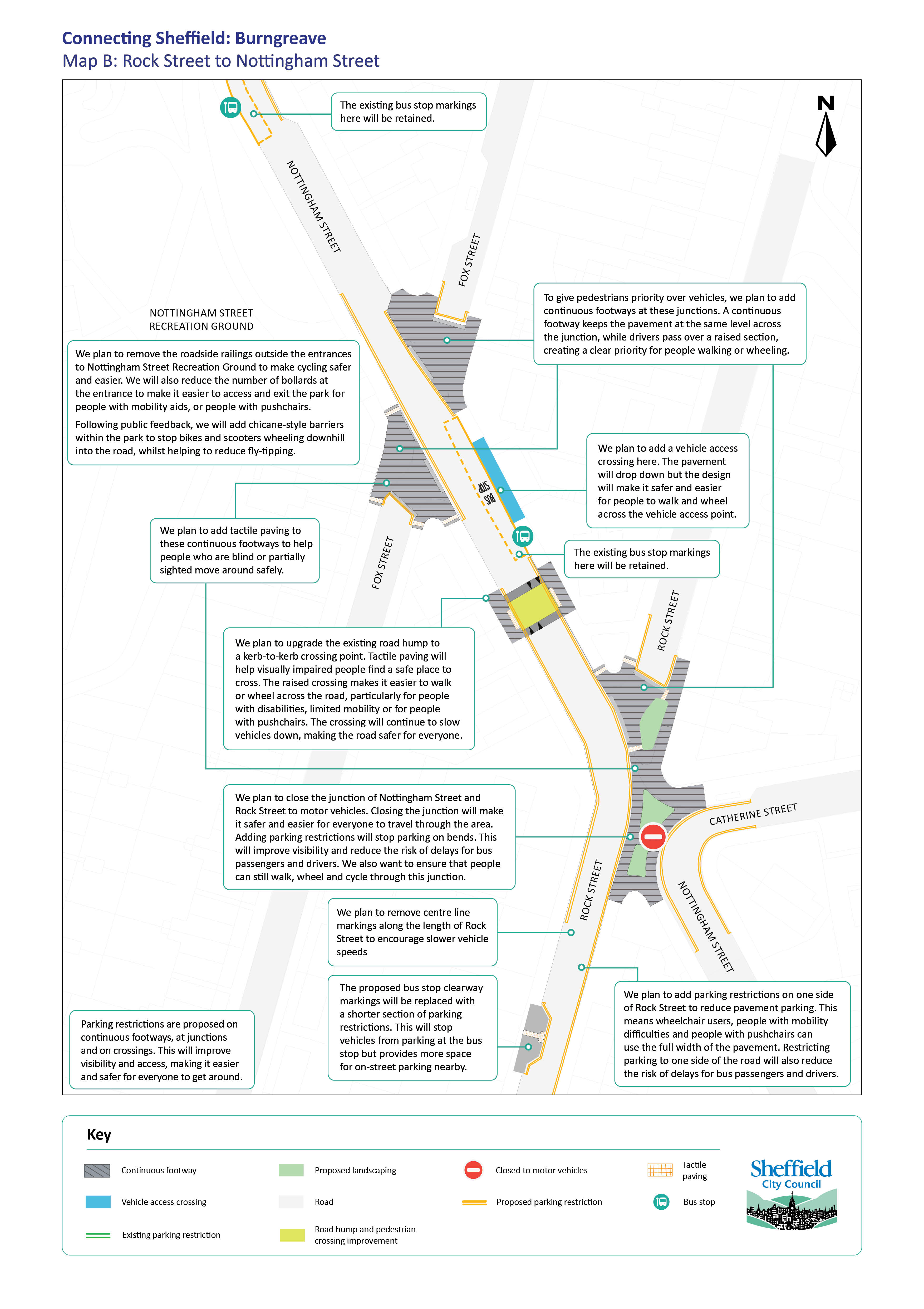 Map B showing proposed improvements between Rock Street and Nottingham Street
Map B shows proposals at the bottom of Nottingham Street and the top of Rock Street including:
- Closure of the junction between Nottingham Street/Catherine St and Rock Street/Nottingham Street to motor vehicles
- Continuous footways at junctions to create priority for people walking or wheeling
- Upgrading the road hump with a kerb-to-kerb crossing point between Rock Street and Fox Street
- Tactile paving at the crossing and at some continuous footways
- Improved vehicle access crossing at the bus stop near Fox Street
- Raised kerbs and tactile paving at bus stops
- Removing roadside railings outside Nottingham Street Recreation Ground
- Replacing some bollards at the entrance of Nottingham Street Recreation Ground with accessible barriers
- Parking restrictions at junctions, on continuous footways, crossing and where the road narrows
- Parking restrictions on bends in the road
View this map as a PDF so that you can zoom in for more detail.
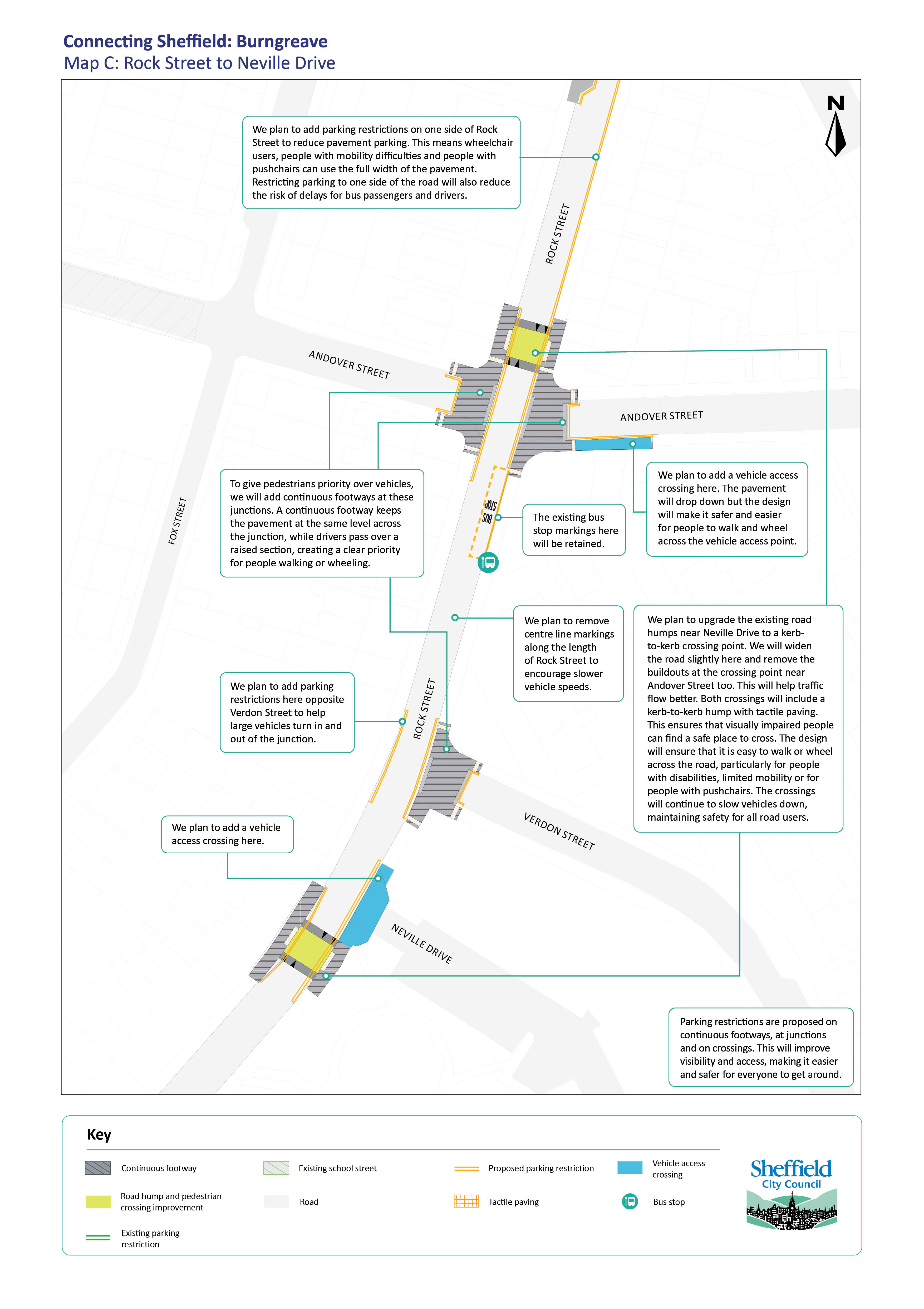 Map C showing proposed improvements between Rock Street and Neville Drive
Map C shows proposals at the top of Rock Street including:
- Continuous footways at Verdon Street and Andover Street junctions to create priority for people walking or wheeling
- Improved road humps with a kerb-to-kerb crossing point near Andover Street and Neville Drive
- Improved vehicle access crossings at Neville Drive and on Andover Street
- Parking restrictions on one side of Rock Street to prevent pavement parking and improve traffic flow
- Parking restrictions at junctions, on continuous footways and crossings
View this map as a PDF so that you can zoom in for more detail.
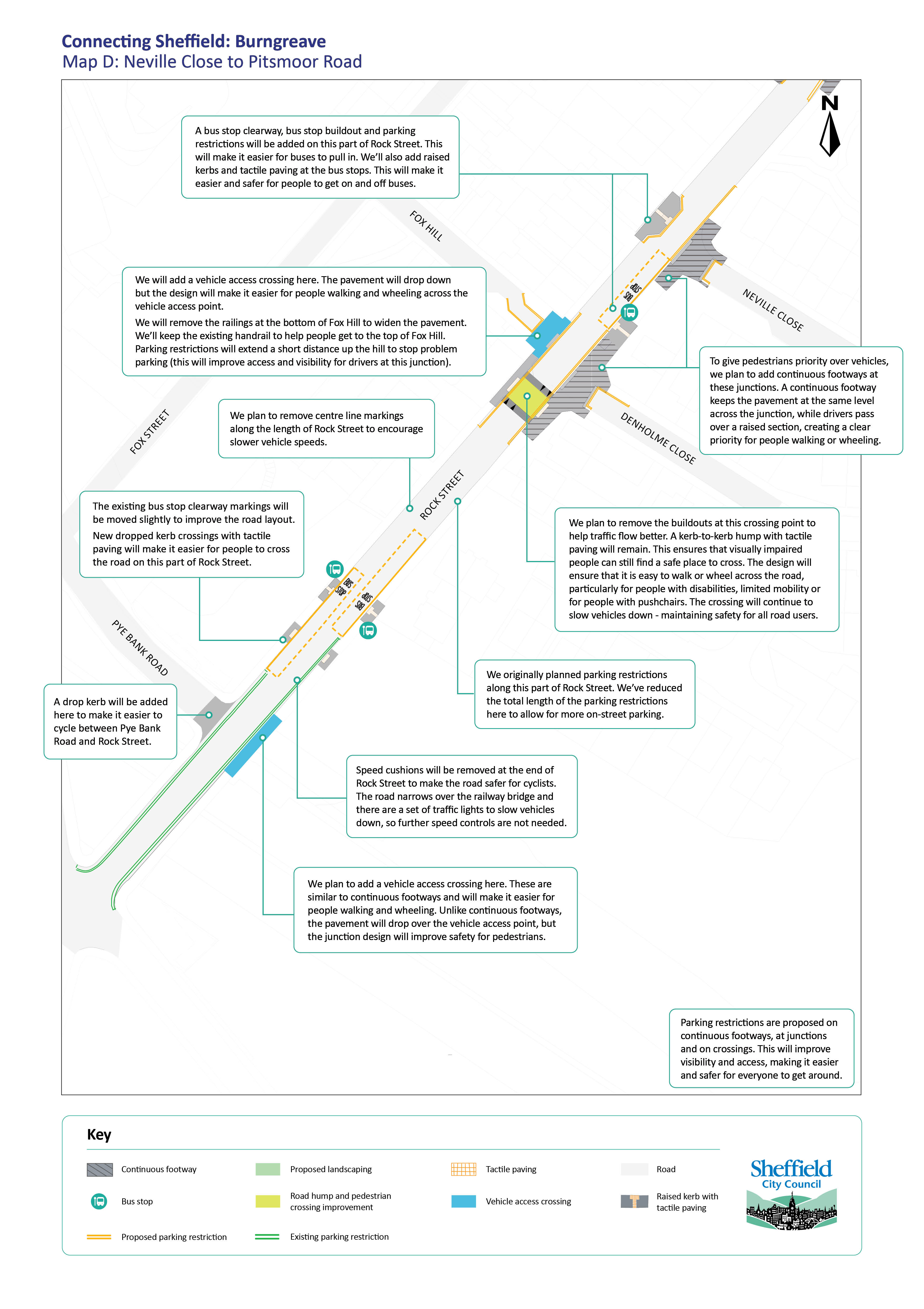 Map D showing proposed improvements from Neville Close to Pitsmoor Road
Map D shows proposals for the bottom of Rock Street from Neville Close to Pye Bank Road including:
- Continuous footways at the junction of Neville Close and Denholme Close, giving priority to people walking and wheeling
- Improved vehicle access crossings at the junction of Fox Hill and opposite Pye Bank Road
- Raised kerbs and tactile paving at bus stops
- A new bus stop clearway between Denholme Close and Neville Close
- A new bus stop buildout with tactile paving and parking restrictions opposite Neville Close
- Removing the buildouts at the existing road hump with kerb-to-kerb crossing near Denholme Close
- Parking restrictions at junctions, on continuous footways and crossings
- Removing roadside removed near Fox Hill
- The handrail at the top of Fox Hill will remain
- New drop kerb with tactile paving added at the bus stops at the bottom of Rock Street near Pye Bank Road
- Speed cushions removed at the end of Rock Street near Pye Bank Road
View this map as a PDF so that you can zoom in for more detail.
How to take part in the TRO consultation
The TRO consultation period takes place between 24 September 2026 and October 2026. During this time, you can support, comment or raise objections about the plans through our Appyway portal.
You will be able view the proposals on the left. Select them to view more details on the screen, then submit your feedback busing the blue 'Respond to Consultation' tab located at the bottom right.
You can also find more information about Traffic Regulation Orders,and any proposed waiting/parking restrictions, through the Appyway link above or by visiting the Sheffield City Council website.
After the TRO consultation ends on 22 October, we will review all comments and objections before a final decision is made. Further details are included in our FAQs section on the right.
More information about the proposed improvements following public consultation
The table below summarises key changes we have made to the proposals following public consultation. The table highlights which improvements form part of the TRO consultation stage. Details of these changes and why we have made them is explained further below in the 'You said, we did' section.
Proposal | Decision | Part of TRO consultation? |
Junction closure: Rock St, Nottingham St, Catherine St | Proceed | Yes |
Junction closure: Pilgrim St, Nottingham St | Replace with continuous footway | Only for complementary parking restrictions |
Continuous footways | Proceed | Only for complementary parking restrictions |
Vehicle access crossings | Proceed | Only for complementary parking restrictions |
Parking restrictions | Proceed with amendments | Yes |
Bus stop parking restrictions | Proceed with amendments | TRO not needed for bus stop clearways, but other parking restrictions will form part of the TRO |
Bus-friendly humps | Proceed. | Only for complementary parking restrictions |
Railings removal | Partial removal | No |
Removal of centre line markings | Proceed | No |
Removal of speed cushion | New proposal to proceed | No |
Drop kerb crossings with tactile paving | Proceed with amendments. New locations added. Two upgraded to bus-friendly road humps | Only for complementary parking restrictions |
Trees and benches | Subject to further design and ground investigations | No but immediate properties will be contacted by letter |
You said, we did
The road closure at the junction of Rock Street, Nottingham Street and Catherine Street will go ahead as planned
Many people agreed that closing this junction to traffic will make the area quieter and safer. Some people are concerned that this will lead to more parking and traffic on nearby streets. Traffic and parking surveys show relatively low numbers of vehicles parking here or driving through the area. Because of this, we expect any increase in traffic or parking on nearby streets to be low.
The current junction can be difficult or unsafe to use. This is especially true for people walking or wheeling, including children, older people and people with disabilities. Closing the junction to vehicle traffic will create a safer and more comfortable route through the area. It will make it easier for people to walk, wheel, cycle and access public transport.
The junction closure and parking restrictions here form part of the TRO consultation process.
The road closure at the junction of Nottingham Street and Pilgrim Street will be replaced with a continuous footway
Some residents told us that closing the junction could make it harder to reach Pilgrim Street from Fox Street. Icy or snowy weather is a concern because Fox Street is steep. Very few vehicles use this junction to access Pilgrim Street and nearby roads. This means that closing the junction would provide limited benefits for people walking, wheeling and cycling. A continuous footway across the side road will make it easier and safer for people to walk and wheel, without affecting access to Pilgrim Street by car.
There are parking restrictions planned to stop parking on continuous footways. These form part of the TRO consultation process.
You can read more about continuous footways in the section below.
Continuous footways and vehicle access crossings will go ahead as planned
Feedback on the proposed continuous footways was mixed. Some people were unsure whether the changes would make a difference. However, most people who took part in the door to door surveys, and most people who walk, wheel or cycle, agreed that the changes would make it easier and safer to travel through the area.
Continuous footways improve priority for people walking and wheeling. They make it easier and safer to cross side roads. A continuous footway is where the pavement continues across side road junctions without a level change. This means that people walking, wheeling or using a mobility aid do not have to step down or back up when crossing the road. Instead, vehicles go up and over ramps on a raised surface. This encourages drivers to slow down helping to improve safety for everyone.
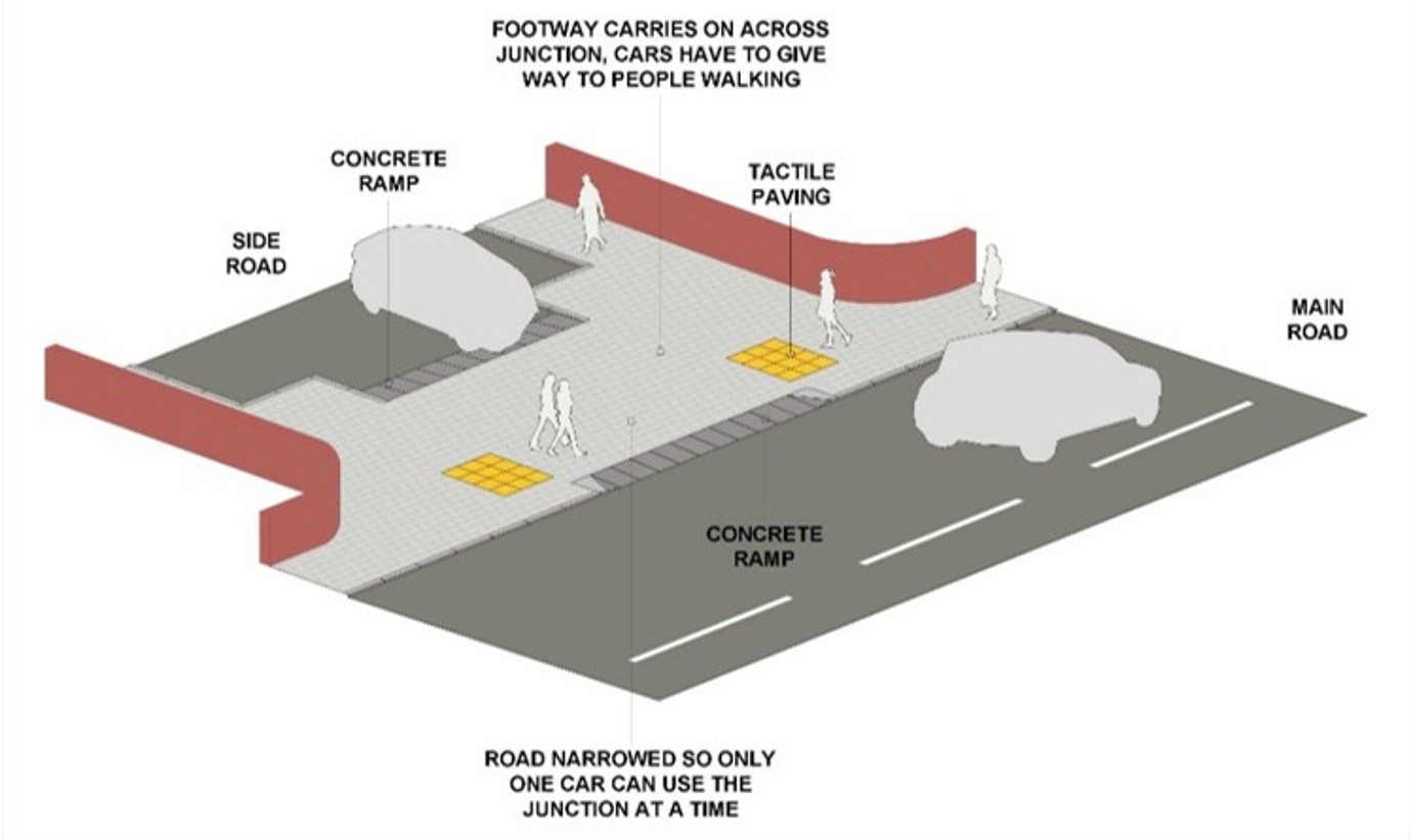 Diagram of a continuous footway
 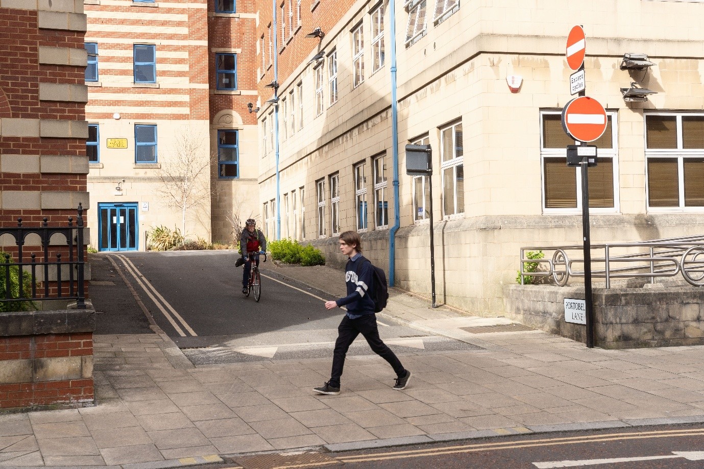 Image of a continuous footway at the junction of Mappin Street and Portobello Lane. (This is an indicative image only. The continuous footway on Rock Street and Nottingham Street will look different).
We are proposing vehicle access crossings where a full continuous footway design is not needed. They are used at driveways or where there are far fewer vehicles crossing the pavement. Access will remain for vehicles, but we aim to make it easier to cross for people walking, wheeling or using a mobility aid.
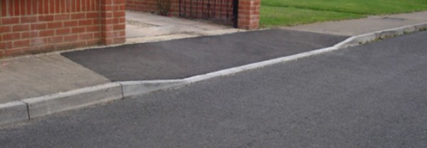 Image of what a vehicle access crossing could look like
 Parking restrictions will go ahead with some changes
Most residents who took part in the door to door surveys, and most people who walk, wheel, cycle or use the bus, agreed that parking restrictions would make journeys safer and easier. Online feedback was mixed. Some people were worried about having less space to park. Others felt parking problems might move onto nearby streets. We did some parking surveys in May and found there is enough road space on local roads to meet parking needs, so we have updated the proposed restrictions.
Restrictions will be shorter than planned at the lower end of Rock Street, between Denholme Close and Pitsmoor Road. This is where the highest numbers of vehicles normally park. Where possible, the we have also reduced the length of restrictions at bus stops.
Restrictions will be extended in other places on Rock Street, Nottingham Street and some side roads. This will help to:
- keep continuous footways and crossing points clear so people can cross safely
- stop people parking on junctions and across driveways, making it easier to see and move around safely
- reduce pavement parking so people can use the full width of the pavement. This includes wheelchair users, people with mobility difficulties and people with pushchairs
- stop people parking on bends and narrow sections of road, making it easier and safer for vehicles to pass safely
- keep bus stops clear so buses can pull in and passengers can get on and off more safely and easily
- stop people parking opposite junctions so that larger vehicles can turn in and out more safely and easily
Any changes to parking restrictions form part of the TRO consultation process.
Bus stop parking restrictions and other improvements will go ahead with minor changes
Most people agree that keeping bus stops clear will make it easier for buses to pull in. This will help passengers get on and off buses more safely and easily. New restrictions will stop vehicles from blocking bus stops.
We will move forward with our plans to make bus stops easier to use by adding raised kerbs and tactile paving. This will make getting on and off the bus easier, particularly for people with disabilities or limited mobility.
The pavement buildout at the bus stop opposite the Rock Store will remain. We will add a new pavement buildout opposite Neville Close as planned. At these two bus stops, we will now replace clearway markings with shorter sections of double yellow lines. This will stop people from parking at the bus stop and will provide more space for on-street parking nearby.
Bus stop clearways and pavement buildouts are not part of the TRO consultation process. Other parking restrictions at bus stops form part of the TRO consultation process.
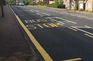 Image of yellow bus-stop 'clearway' marking
 Changes to road humps will go ahead
Most people agree with plans for improved road humps. The new road humps are designed to be more comfortable than the existing humps. They will continue to help to slow vehicles down, making roads safer for everyone and easier to cross. They create raised crossing points, and tactile paving will help blind and partially sighted people cross more safely.
Raised crossings remove the need to step down into the road and back up onto the pavement. This will make crossing easier and safer for people with disabilities, people with limited mobility and people with pushchairs. We intend to add two more of these road humps by upgrading two existing speed humps on Nottingham Street (one between Rock Street and Fox Street, and one between Pilgrim Street and Nottingham Cliff). We also plan to extend some parking restrictions to keep these crossing points clear for people who are walking and wheeling.
These crossings, road humps and buildouts are not part of the TRO consultation process.
Proposed parking restrictions designed to keep these interventions clear of parked cars do form part of the TRO consultation period.
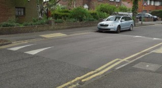 Image of a kerb-to-kerb bus friendly road hump
 Some railings and bollards will be removed
Removing railings will create more pavement space for people walking and wheeling. Railings next to the road can also be dangerous to people cycling when drivers pass too closely.
We will remove railings will outside the Nottingham Street Recreation Ground. we will also remove some bollards at the entrances. This will make it easier for everyone to access the park. We will also add new accessible barriers which will help prevent fly-tipping, and will slow bikes and scooters.
We will also remove railings at the junction of Rock Street and Fox Hill. The railing at the top of Fox Hill will remain. This will provide a handrail to help people walk up and down the hill safely, especially in bad weather.
Railings and bollards are not part of the TRO consultation process.
Centre-line markings on the road will be removed
We will remove the centre line marking from most of Rock Street and Nottingham Street to help reduce vehicle speeds. With the line removed, drivers are more likely to slow down and take care when approaching other vehicles. This change also encourages people who are cycling to ride a safe distance from the kerb.
Removing centre line markings is not part of the TRO consultation process.
Existing speed cushions at the bottom of Rock Street will be removed
Removing speed cushions makes roads safer for people who are cycling. There are traffic lights at the bottom of Rock Street, near where the road becomes narrow over the railway bridge, so there are no further measures needed to reduce vehicle speeds here.
This is not part of the TRO consultation process.
More drop kerb crossings with tactile paving will be added
Drop kerbs and tactile paving provide easier points for people to cross the road. We will add these at the bus stops at the bottom of Rock Street (near Pye Bank Road).
Drop kerb crossings and tactile paving are not part of the TRO consultation process.
Some street trees and benches are being considered
Low level planting could be difficult to maintain because of litter and pests. However, there is support for measures to improve local streets. Several street trees will be planted if we can avoid underground pipes, cables and services. We will add several benches where there is enough space on the pavement.
Street trees, benches and other street furniture are not part of the TRO process. However, we will write to any properties directly impacted by these sorts of proposals.
Other issues in Burngreave
Throughout the consultation, we received feedback on a broad range of issues in Burngreave. Most of these relate to travel and transport either directly or indirectly.
We have provided a response to this wider feedback in our 'Summary of responses to other feedback' document.
A summary of the public feedback during the previous public consultation is available in our Consultation Report.
View our summary of responses to the previous consultation survey.
Please use the contact details at the end of this webpage if you have questions about the proposed changes that do not form part of the TRO consultation process.
Next steps
We need to secure more funding to take our plans to construction. This needs to be approved by Sheffield City Council and the South Yorkshire Mayoral Combined Authority. If successful, we plan to start construction in summer 2027. We will continue to share updates, answer questions, and provide information on this webpage and through our other communication channels.
Stay up to date
Get the latest information about transport projects across Sheffield by signing up to receive our emails. You will receive updates straight to your inbox.
Contact us
If you have any questions, you can contact the project team through any of the following channels. These channels are monitored 9am to 5pm, Monday to Friday, outside of bank holidays:
- Email: info@connecting-sheffield.co.uk
- 9am-5pm Freephone: 0808 196 5105
- Freepost: Freepost Connecting SHF
-
 Connecting Sheffield Burngreave Consultation Report (9.71 MB) (pdf)
-
Summary of responses to previous consultation (143 KB) (pdf)
-
Summary of responses to other feedback during previous consultation (143 KB) (pdf)
-
Overview map of Burngreave (6.06 MB) (pdf)
-
Map A of Christ Church Road to Rising Street (6.07 MB) (pdf)
-
Map B of Rock Street to Nottingham Street (6.08 MB) (pdf)
-
Map C of Rock Street to Neville Drive (6.06 MB) (pdf)
-
Map D of Neville Close to Pitsmoor Road (6.04 MB) (pdf)
-
All Burngreave maps (30.3 MB) (pdf)
