Connecting Sheffield: Northern Communities - Phase One

The north of Sheffield is home to communities where lots of people rely on buses, walking and wheeling for everyday journeys. Around one in three households in this area does not have access to a car.

Connecting Sheffield: Northern Communities Phase One aims to help improve journeys for everyone in north Sheffield.

We are consulting on proposals for changes around Firth Park, Longley and Firshill. We are also proposing some smaller improvements in other places along and around Barnsley Road.

The changes aim to make journeys safer, more reliable and better connected. This should make it easier for people to get to work, school, healthcare, local services and other everyday places.

We have used feedback from local people to shape the project. That feedback includes concerns around:

  • bus reliability
  • road safety
  • parking
  • accessibility.

Phase One is the first stage of a longer-term programme of improvements that we will develop when there is more funding available.
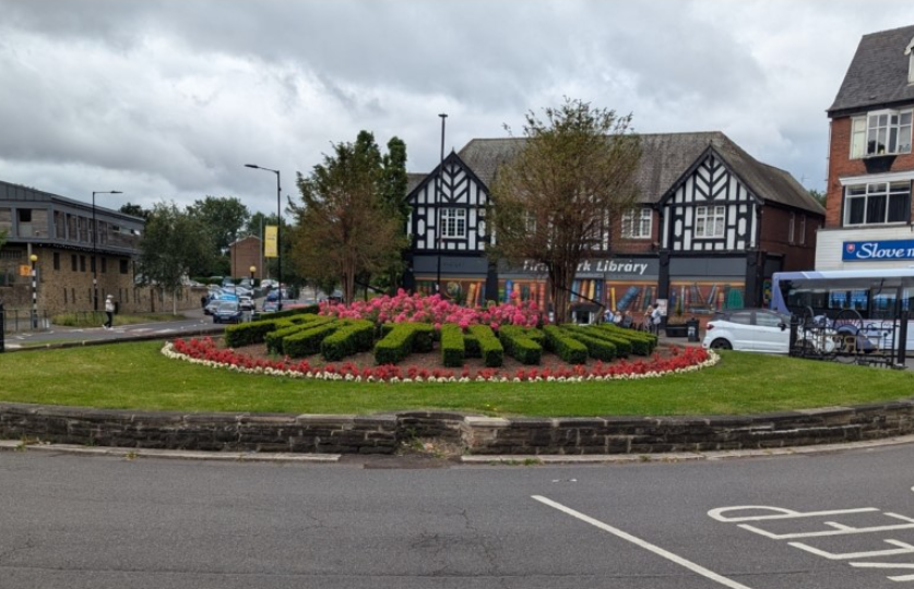

An image showing buildings and a road in front of a roundabout on Firth Park Road in north Sheffield An image of Firth Park Road in north Sheffield


What we want to achieve

We want to:

  • Make streets safer and easier to use for everyone.
  • Make bus journeys more reliable by making it easier for buses to move through busy areas and reducing delays.
  • Reduce the impact of people parking inconsiderately. This will help to keep roads, pavements, bus stops and junctions clear and accessible.
  • Improve access to everyday things like including work, school, healthcare, shops and local services.
  • Make connections to important places stronger, like the Northern General Hospital and key local centres.
  • Support local communities and businesses by making town and district centres easier to reach and move around.

What we are proposing

Phase One focuses on improvements at key junctions and local centres along Barnsley Road. We have outlined what we are proposing in each location below.
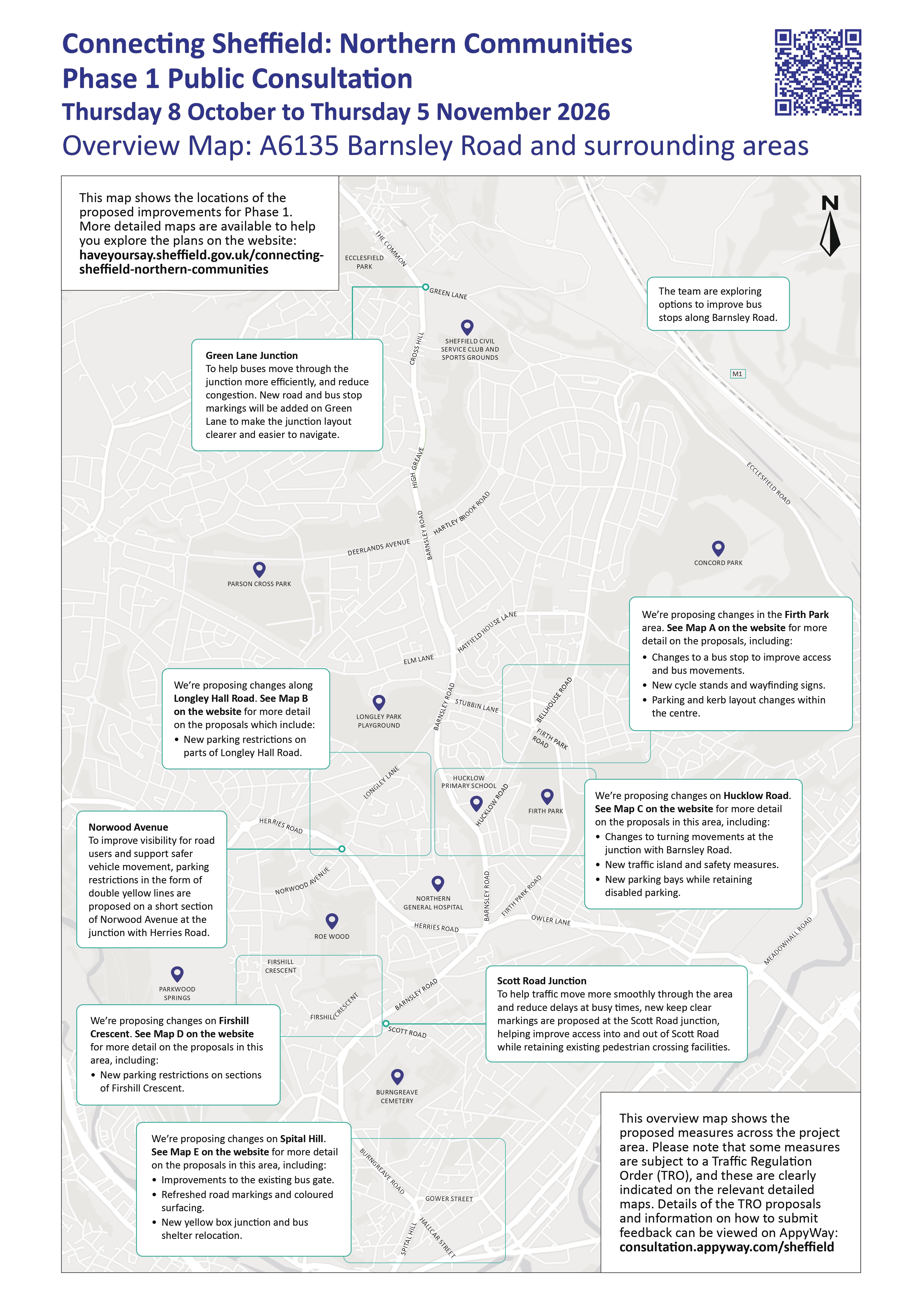
A map showing plans to improve junctions and streets around Barnsley Road to make them easier and safer to use. The overview map shows our proposals for Barnsley Road and surrounding areas


View this map as a PDF so that you can zoom in for more detail.

Some of our proposals will require a Traffic Regulation Order (TRO). You can find out more about TROs including the locations where they will be required in the information below.

Traffic Regulation Orders (TROs)

Some of our proposals will need a Traffic Regulation Order (TRO). A Traffic Regulation Order is a legal process that allows councils to change the way roads are used. This can include introducing parking, waiting and certain traffic movement restrictions.

Not all of the proposals in Phase One need a TRO. We have outlined where a TRO is needed and explained which measures are subject to the process in the information below.


Firth Park
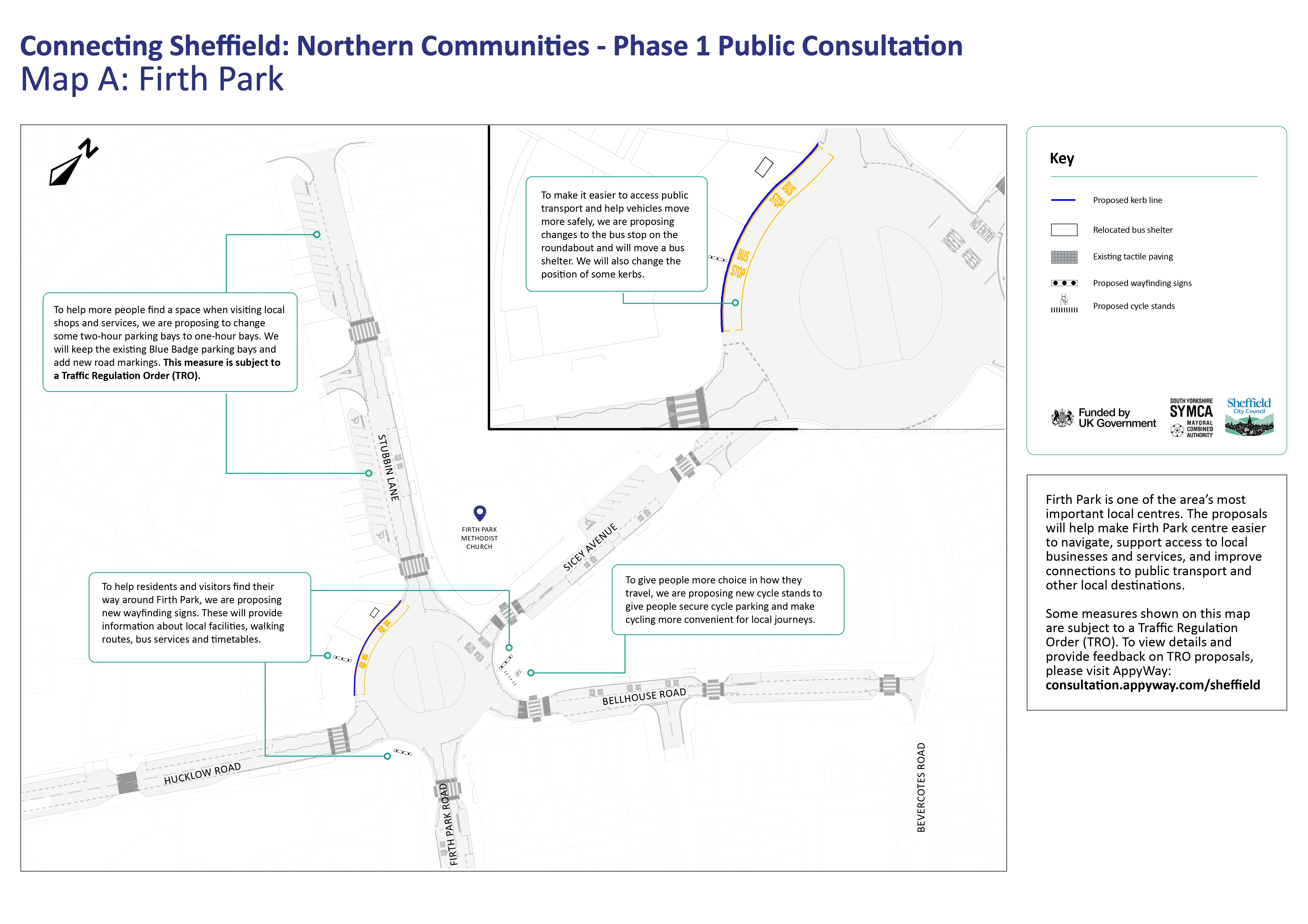
A map showing improvement plans for Firth Park including new cycle stands, new wayfinding signs, changes to parking bays and changes to the bus stop at the roundabout. Map A showing proposed improvements for Firth Park

Map A shows proposals in Firth Park centre, including:

  • Changes to the bus stop on the roundabout and moving the bus shelter.
  • Changing some kerbs to help vehicles move more safely.
  • Adding cycle stands and signs to help people find local facilities, walking routes and bus services.
  • Changing some two-hour parking bays to one-hour bays and keeping the existing Blue Badge bays.

View this map as a PDF so that you can zoom in for more detail.

Firth Park is an important local centre. It is home to shops, services, public transport connections and community facilities that are used by people from across north Sheffield. We are proposing some improvements to make it easier to access these destinations. They will also help people move around the area more easily and safely.

Our proposals include:

  • Improving access to public transport by making changes to bus stops in the centre. This includes moving a bus shelter and making changes to the bus stop on the roundabout.
  • Supporting safer vehicle movements by changing where some kerb lines are in the centre.
  • Helping people find their way around with new wayfinding signs. These will give information about local amenities, walking routes and public transport information.
  • Keeping parking available for customers and visitors with updated parking bay markings. We also propose to make changes to some waiting restrictions, and convert some two-hour parking bays to one-hour bays to make spaces available more often.
  • Keeping existing Blue Badge parking bays with new road markings.
  • Making it easier for people to cycle with new cycle stands to give more cycle parking.

These changes aim to make Firth Park easier to access, and improve connections to local businesses and services. They will also make it safer to move around the centre and enable more people to choose to use public transport, walk, wheel or cycle for their journeys.

Traffic Regulation Order

Some of the parking and waiting restriction changes we are proposing need a Traffic Regulation Order.

If you would like to formally support, object to or comment on these proposals, you can find out how to do that in the 'How to comment on TRO measures' section.

Longley Hall Road and Norwood Avenue
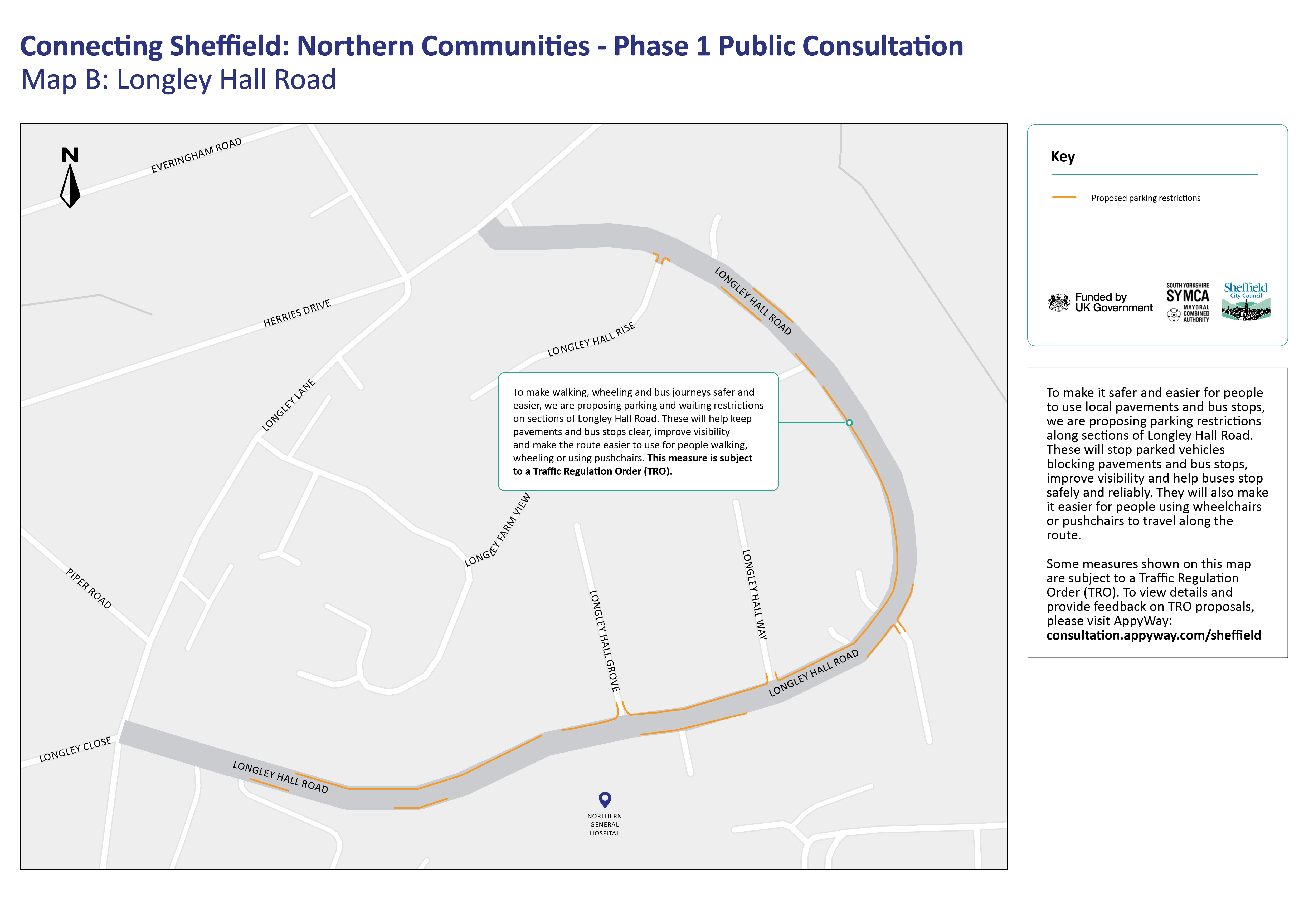
Map of Longley Hall Road showing plans for parking restrictions along sections of the road to stop parked vehicles blocking pavements and bus stops, improve visibility and help buses stop safely and reliably. Map B showing proposed improvements for Longley Hall Road

Map B shows proposals along sections of Longley Hall Road, including:

  • Parking and waiting restrictions to keep pavements and bus stops clear.
  • Stopping parked vehicles from blocking pavements and bus stops.
  • Improving visibility for people travelling through the area.
  • Making the route clearer for buses and people walking, wheeling or using pushchairs.

View this page as a PDF so that you can zoom in for more detail.

Longley Hall Road is used by pedestrians, bus passengers, residents and people travelling through the area. Existing parking arrangements can sometimes mean that vehicles obstruct footways. This affects visibility and can block access to bus stops.

The proposals aim to make it safer and easier for people to move around the area, while also supporting more reliable bus journeys.

Our proposals include:

  • New double yellow lines in key places along Longley Hall Road.
  • New double yellow lines along Norwood Avenue, at the junction with Herries Road.

These restrictions are designed to address where parked vehicles can obstruct pavements. This makes walking and wheeling more difficult, reduces visibility, blocks access to bus stops, and makes it difficult for buses to stop safely and reliably.

The proposed changes will help keep footways clear for everyone. This includes wheelchair users, people with prams and those with mobility impairments. They will also help improve visibility and make sure that bus stops are accessible.

Traffic Regulation Order

The proposed double yellow line restrictions need a Traffic Regulation Order.

If you would like to formally support, object to or comment on these proposals, you can find out how to do that in the 'How to comment on TRO measures' section.

Hucklow Road
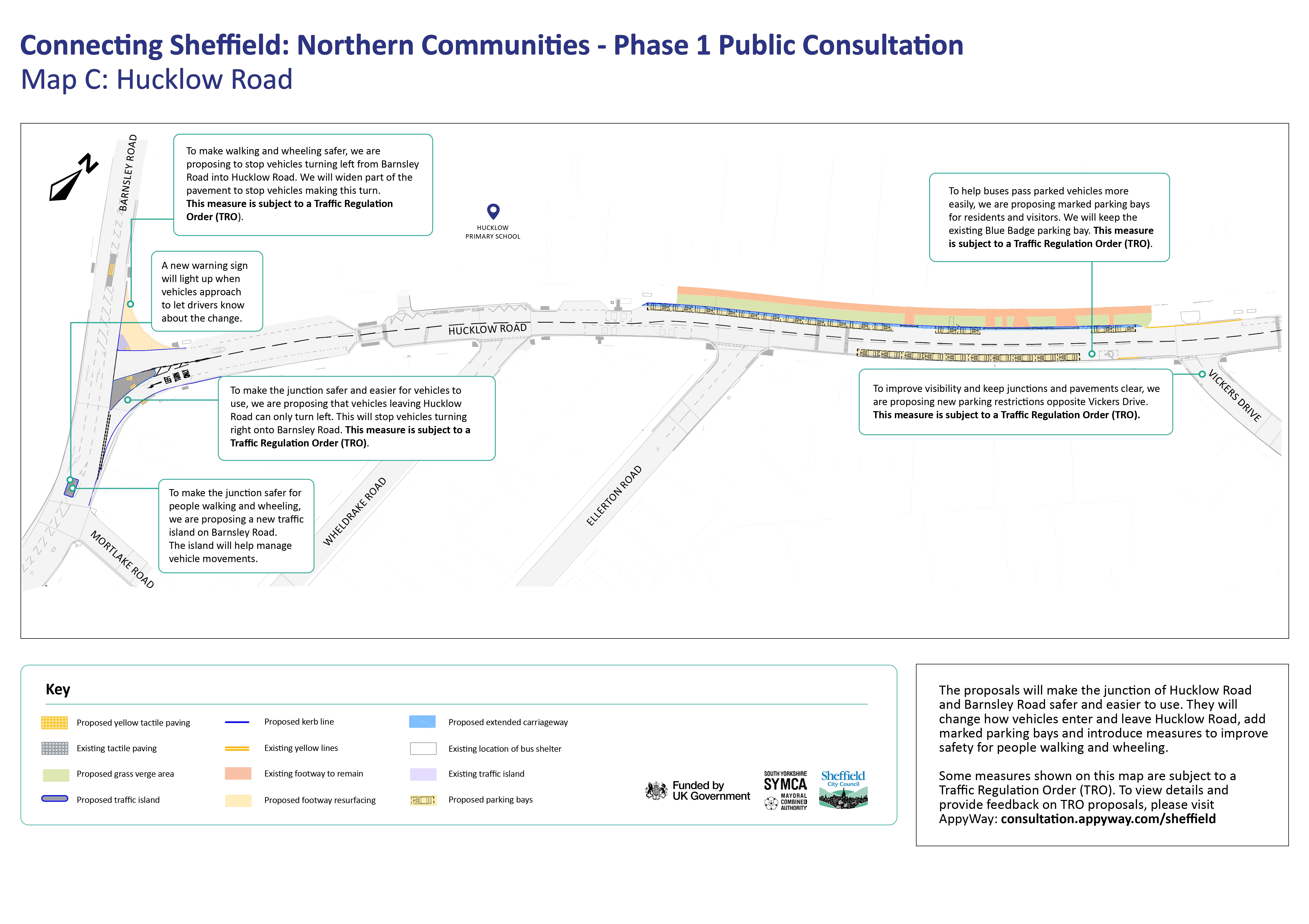
A map showing plans to change how vehicles enter and leave Hucklow Road, proposals to add marked parking bays and measures to improve safety for people walking and wheeling.Map C showing proposed improvements for Hucklow Road

Map C shows proposals at Hucklow Road, including:

  • Vehicles leaving Hucklow Road would only be able to turn left onto Barnsley Road.
  • Vehicles travelling on Barnsley Road would only be able to turn right into Hucklow Road.
  • Widening part of the pavement and adding a traffic island to make it easier and safer to cross.
  • Adding marked parking bays and keeping the existing Blue Badge bay.

View this map as a PDF so that you can zoom in for more detail.

We are proposing changes at Hucklow Road to improve safety for people walking and wheeling, simplify vehicle movements at the junction and help buses travel through the area more reliably.

Feedback we received from the local community showed concerns around road safety, vehicle movements and parked vehicles affecting visibility and traffic flow.

Our proposals include:

  • A footway build-out to stop vehicles turning left into Hucklow Road from Barnsley Road, reducing conflicts at the junction.
  • A new left-turn-only arrangement for vehicles leaving Hucklow Road. This will stop right turns onto Barnsley Road and make vehicle movements simpler.
  • A new traffic island to help guide vehicles and make it safer for people to cross the road.
  • A warning sign that is activated by vehicles to alert approaching drivers to the new junction layout.
  • New parking bays for residents and visitors, helping to organise parking more effectively and create additional space for buses to pass.
  • New parking restrictions opposite Vickers Drive to stop people parking inconsiderately, improve visibility and keep routes clear.
  • Keeping the existing Blue Badge parking bay.
  • Keeping the existing bus stops and bus shelters.

Together, these measures aim to improve safety, reduce conflicts between vehicles and support better bus journeys.

Traffic Regulation Order

The proposed turning restrictions, parking restrictions and associated waiting restrictions need a Traffic Regulation Order.

If you would like to formally support, object to or comment on these proposals, you can find out how to do that in the 'How to comment on TRO measures' section.

Firshill Crescent
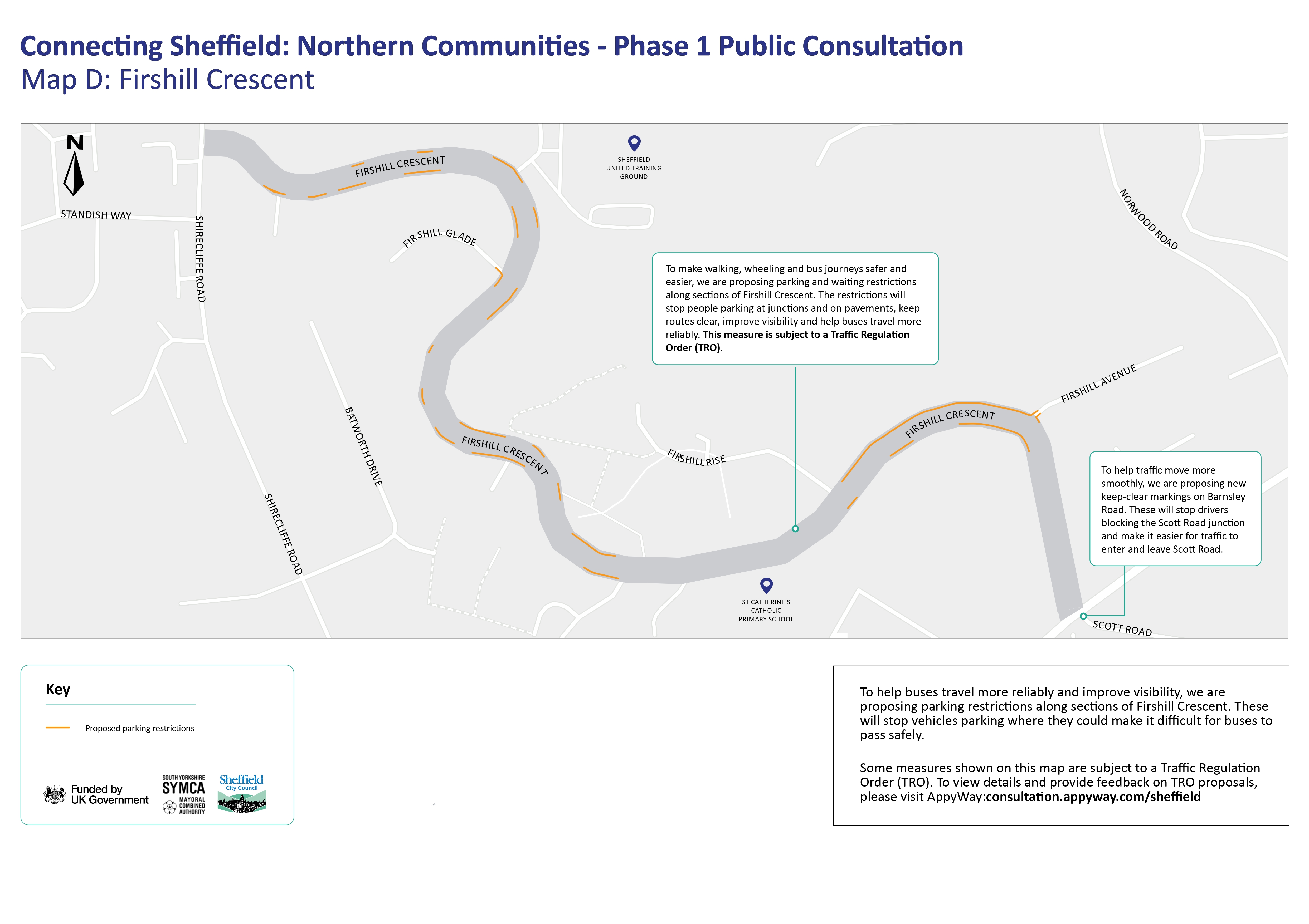

A map showing plans to introduce parking restrictions along sections of Firshill Crescent. to improve bus reliability and visibility. Map D showing proposed improvements for Firshill Crescent

Map D shows proposals at Firshill Crescent and Scott Road, including:

  • Introducing parking and waiting restrictions along sections of Firshill Crescent.
  • Keeping junctions, pavements and bus stops clear.
  • Improving visibility and making it easier for buses and other vehicles to pass.
  • Adding "Keep clear" markings to stop vehicles from blocking the Scott Road junction.

View this map as a PDF so that you can zoom in for more detail.

Firshill Crescent is an important route for local bus services. Parked vehicles can sometimes make it difficult for buses to travel through the area safely and efficiently. This can delay services and reduce visibility for other road users.

The proposals aim to make bus journeys more reliable, make it safer to move through the area and improve visibility along the route.

In this area, we are proposing new double yellow lines along sections of Firshill Crescent.

These restrictions will help reduce parking in places where it can:

  • make it difficult for buses to pass safely
  • reduce visibility for people driving, walking, wheeling or crossing the road
  • create pinch points that affect traffic flow.

By keeping key sections of the route clear, the proposals will help buses move through the area more easily and support safer journeys for everyone.

Traffic Regulation Order

The proposed double yellow line restrictions need a Traffic Regulation Order.

If you would like to formally support, object to or comment on these proposals, you can find out how to do that in the 'How to comment on TRO measures' section.

Spital Hill
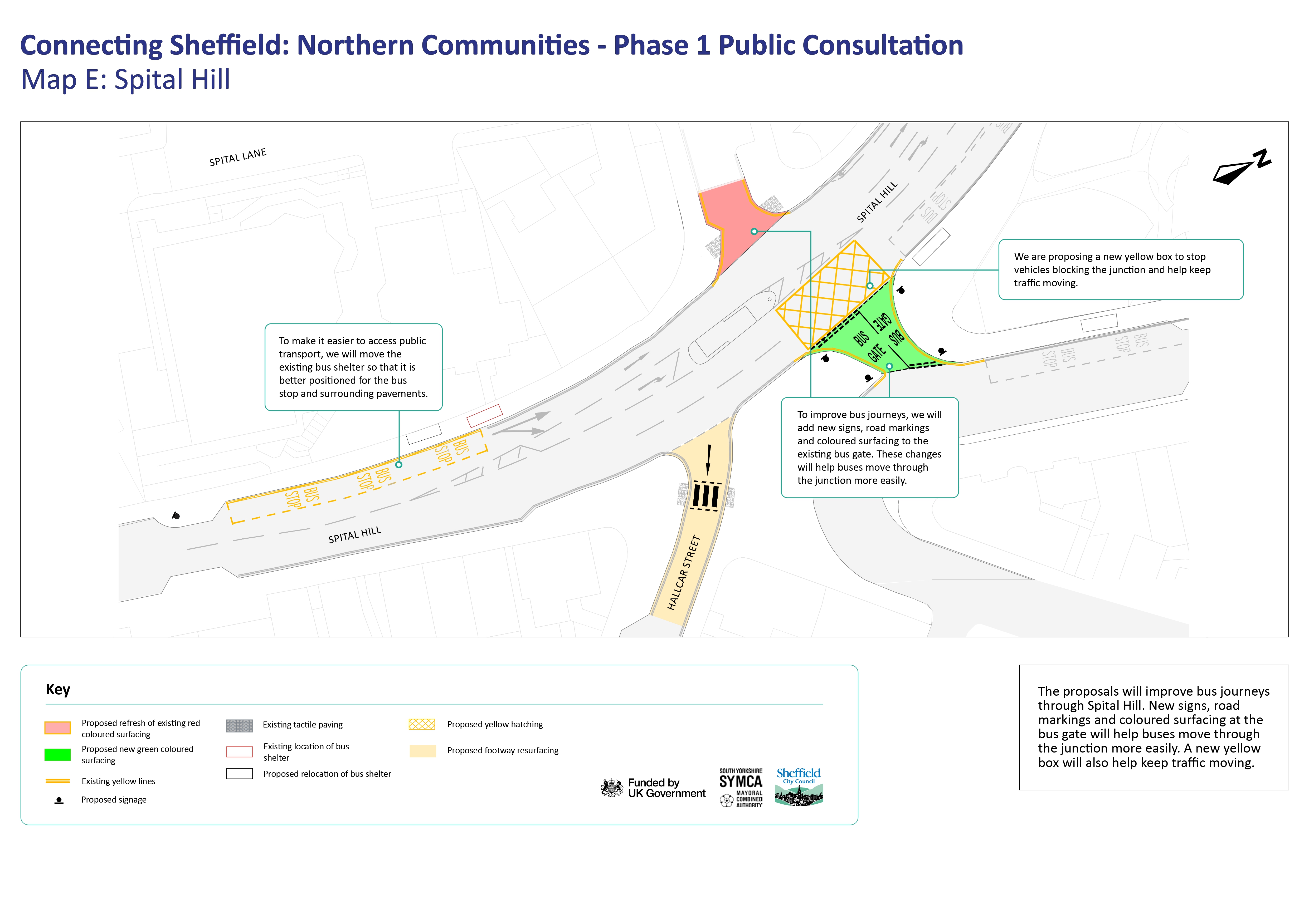
A map showing how proposals could improve bus journeys through Spital Hill through new signs, road markings and coloured surfacing at the bus gate and a new yellow box to keep traffic moving.Map E showing proposed improvements for Spital Hill


Map E shows proposals at Spital Hill, including:


  • Adding signs, road markings and coloured surfacing at the existing bus gate.
  • Adding a yellow box to help prevent vehicles from blocking the junction.
  • Moving a bus shelter.

View this map as a PDF so that you can zoom in for more detail.


Spital Hill is one of the busiest locations on the route between north Sheffield and the city centre. We are proposing improvements to help buses and other authorised vehicles travel more reliably, reduce delays and improve access to public transport facilities.

Our proposals include:

  • New signs, road markings and coloured surfacing to reinforce the existing bus gate.
  • A new yellow box junction to help stop vehicles blocking the junction when traffic is queuing. This will help traffic flow more smoothly.
  • Moving an existing bus shelter.

Other proposed measures

Alongside the main proposals at Firth Park, Spital Hill, Hucklow Road, Longley Hall Road and Firshill Crescent, we are also proposing a number of smaller improvements at other locations across north Sheffield. These measures aim to:

  • make bus journeys more reliable
  • reduce delays
  • improve visibility
  • help all traffic move more easily through key junctions and local roads.

We are also considering future improvements to bus stop facilities along Barnsley Road. This could include upgraded shelters, seating and real-time service information.

Green Lane junction

At Green Lane, we are proposing to make movements clearer for everyone and help reduce delays by refreshing road and bus stop markings. This will make the junction layout clearer and easier to navigate.

These changes aim to help buses move through the junction more easily, make bus journeys more reliable and help all traffic move through the junction more smoothly.

Scott Road junction

To help keep traffic moving and help people enter and leave Scott Road during busy times, we are proposing new "Keep Clear" road markings at the junction with Barnsley Road.

Barnsley Road

In addition, we are considering future improvements to bus stop facilities along Barnsley Road, including upgraded shelters, seating and real-time service information.

Proposals that need a TRO

The following proposals need a Traffic Regulation Order:

  • Changes to parking and waiting restrictions in Firth Park.
  • Turning restrictions, parking restrictions and associated waiting restrictions on Hucklow Road.
  • Proposed double yellow line restrictions on Longley Hall Road.
  • Proposed double yellow line restrictions on Firshill Crescent.
  • Proposed parking restrictions on Norwood Avenue.

The rest of the proposals in the consultation do not need a Traffic Regulation Order.

Have your say on the proposals

We are currently consulting with the local community to explain our plans, share information, and listen to local views, which we will use to develop and refine our proposals further.

The consultation is open from Thursday 8 October and will close at 11:59pm on Thursday 5 November.


Complete our survey

You can let us know your views by completing our survey by clicking here: [link to survey]

Printed copies of the survey are available on request. If you require information in an alternative format, please contact us through our dedicated communications channels, which you can find below.

You can also share your feedback and ask any questions you may have by getting in touch with the Connecting Sheffield Engagement Team. Contact details are below.


Attend our drop-in events

You can also come along to one of our drop-in events where you can learn more about the proposals, speak to the project team and ask questions.

We will be holding two drop-in events at Firth Park Library, 443 Firth Park Road, Sheffield, S5 6QQ.

  • Event 1: Monday 19 October 2026, 12.30pm to 4.30pm
  • Event 2: Wednesday 21 October 2026, 3pm to 7pm


How to comment on TRO measures

Some of the Phase 1 proposals, including parking restrictions and changes to traffic movements, require Traffic Regulation Orders (TROs).

A TRO is a legal process used by local authorities to introduce or change restrictions on roads.

Not all Phase 1 proposals require a TRO. Throughout this webpage, we have identified where a TRO applies.

The public consultation and TRO consultation will run alongside one another. The public consultation is an opportunity to comment on the overall Connecting Sheffield: Northern Communities – Phase 1 proposals.

The TRO consultation allows you to formally support, object to or comment on the specific proposals that require legal approval.

Details of the proposed TROs are available on the AppyWay consultation website: https://consultation.appyway.com/sheffield. You can formally support, object to or comment on the proposals through AppyWay or by emailing orders@sheffield.gov.uk. If you are objecting, please state the grounds for your objection. Responses must be submitted by Thursday 5 November 2026.

You can also send comments or objections through the Connecting Sheffield consultation channels above. We will forward these to the Council’s Traffic Regulations team for consideration. We will consider all feedback as part of the consultation and decision-making process.

Please note: the AppyWay consultation website only shows what is proposed. To view existing restrictions, visit the AppyWay streets website.


Next steps

We are committed to keeping the local community informed and involved throughout this project. As we consult with residents, businesses and local groups, and subsequently advertise the Traffic Regulation Order, we will carefully review all feedback and comments we receive. This feedback will play an important role in shaping our final decision on whether to proceed with the proposed changes.

If we decide to move forward, the next steps would be to finalise the Phase 1 designs and confirm a timeline for construction and installation. We will also come back to communities to share plans for any future phases of Northern Communities.

In the meantime, we will continue to share updates, answer questions and provide information via this webpage and through our dedicated communication channels, listed below.


Keep up to date on projects in your area

Stay up to date with projects happening in your area by signing up signing up to receive our emails. You'll receive updates straight to your inbox.


Contact us

If you have any questions, you can contact the project team through any of the following channels. These channels are monitored 9am to 5pm, Monday to Friday outside of Bank Holidays:

The north of Sheffield is home to communities where lots of people rely on buses, walking and wheeling for everyday journeys. Around one in three households in this area does not have access to a car.

Connecting Sheffield: Northern Communities Phase One aims to help improve journeys for everyone in north Sheffield.

We are consulting on proposals for changes around Firth Park, Longley and Firshill. We are also proposing some smaller improvements in other places along and around Barnsley Road.

The changes aim to make journeys safer, more reliable and better connected. This should make it easier for people to get to work, school, healthcare, local services and other everyday places.

We have used feedback from local people to shape the project. That feedback includes concerns around:

  • bus reliability
  • road safety
  • parking
  • accessibility.

Phase One is the first stage of a longer-term programme of improvements that we will develop when there is more funding available.


An image showing buildings and a road in front of a roundabout on Firth Park Road in north Sheffield An image of Firth Park Road in north Sheffield


What we want to achieve

We want to:

  • Make streets safer and easier to use for everyone.
  • Make bus journeys more reliable by making it easier for buses to move through busy areas and reducing delays.
  • Reduce the impact of people parking inconsiderately. This will help to keep roads, pavements, bus stops and junctions clear and accessible.
  • Improve access to everyday things like including work, school, healthcare, shops and local services.
  • Make connections to important places stronger, like the Northern General Hospital and key local centres.
  • Support local communities and businesses by making town and district centres easier to reach and move around.

What we are proposing

Phase One focuses on improvements at key junctions and local centres along Barnsley Road. We have outlined what we are proposing in each location below.

A map showing plans to improve junctions and streets around Barnsley Road to make them easier and safer to use. The overview map shows our proposals for Barnsley Road and surrounding areas


View this map as a PDF so that you can zoom in for more detail.

Some of our proposals will require a Traffic Regulation Order (TRO). You can find out more about TROs including the locations where they will be required in the information below.

Traffic Regulation Orders (TROs)

Some of our proposals will need a Traffic Regulation Order (TRO). A Traffic Regulation Order is a legal process that allows councils to change the way roads are used. This can include introducing parking, waiting and certain traffic movement restrictions.

Not all of the proposals in Phase One need a TRO. We have outlined where a TRO is needed and explained which measures are subject to the process in the information below.


Firth Park

A map showing improvement plans for Firth Park including new cycle stands, new wayfinding signs, changes to parking bays and changes to the bus stop at the roundabout. Map A showing proposed improvements for Firth Park

Map A shows proposals in Firth Park centre, including:

  • Changes to the bus stop on the roundabout and moving the bus shelter.
  • Changing some kerbs to help vehicles move more safely.
  • Adding cycle stands and signs to help people find local facilities, walking routes and bus services.
  • Changing some two-hour parking bays to one-hour bays and keeping the existing Blue Badge bays.

View this map as a PDF so that you can zoom in for more detail.

Firth Park is an important local centre. It is home to shops, services, public transport connections and community facilities that are used by people from across north Sheffield. We are proposing some improvements to make it easier to access these destinations. They will also help people move around the area more easily and safely.

Our proposals include:

  • Improving access to public transport by making changes to bus stops in the centre. This includes moving a bus shelter and making changes to the bus stop on the roundabout.
  • Supporting safer vehicle movements by changing where some kerb lines are in the centre.
  • Helping people find their way around with new wayfinding signs. These will give information about local amenities, walking routes and public transport information.
  • Keeping parking available for customers and visitors with updated parking bay markings. We also propose to make changes to some waiting restrictions, and convert some two-hour parking bays to one-hour bays to make spaces available more often.
  • Keeping existing Blue Badge parking bays with new road markings.
  • Making it easier for people to cycle with new cycle stands to give more cycle parking.

These changes aim to make Firth Park easier to access, and improve connections to local businesses and services. They will also make it safer to move around the centre and enable more people to choose to use public transport, walk, wheel or cycle for their journeys.

Traffic Regulation Order

Some of the parking and waiting restriction changes we are proposing need a Traffic Regulation Order.

If you would like to formally support, object to or comment on these proposals, you can find out how to do that in the 'How to comment on TRO measures' section.

Longley Hall Road and Norwood Avenue

Map of Longley Hall Road showing plans for parking restrictions along sections of the road to stop parked vehicles blocking pavements and bus stops, improve visibility and help buses stop safely and reliably. Map B showing proposed improvements for Longley Hall Road

Map B shows proposals along sections of Longley Hall Road, including:

  • Parking and waiting restrictions to keep pavements and bus stops clear.
  • Stopping parked vehicles from blocking pavements and bus stops.
  • Improving visibility for people travelling through the area.
  • Making the route clearer for buses and people walking, wheeling or using pushchairs.

View this page as a PDF so that you can zoom in for more detail.

Longley Hall Road is used by pedestrians, bus passengers, residents and people travelling through the area. Existing parking arrangements can sometimes mean that vehicles obstruct footways. This affects visibility and can block access to bus stops.

The proposals aim to make it safer and easier for people to move around the area, while also supporting more reliable bus journeys.

Our proposals include:

  • New double yellow lines in key places along Longley Hall Road.
  • New double yellow lines along Norwood Avenue, at the junction with Herries Road.

These restrictions are designed to address where parked vehicles can obstruct pavements. This makes walking and wheeling more difficult, reduces visibility, blocks access to bus stops, and makes it difficult for buses to stop safely and reliably.

The proposed changes will help keep footways clear for everyone. This includes wheelchair users, people with prams and those with mobility impairments. They will also help improve visibility and make sure that bus stops are accessible.

Traffic Regulation Order

The proposed double yellow line restrictions need a Traffic Regulation Order.

If you would like to formally support, object to or comment on these proposals, you can find out how to do that in the 'How to comment on TRO measures' section.

Hucklow Road

A map showing plans to change how vehicles enter and leave Hucklow Road, proposals to add marked parking bays and measures to improve safety for people walking and wheeling.Map C showing proposed improvements for Hucklow Road

Map C shows proposals at Hucklow Road, including:

  • Vehicles leaving Hucklow Road would only be able to turn left onto Barnsley Road.
  • Vehicles travelling on Barnsley Road would only be able to turn right into Hucklow Road.
  • Widening part of the pavement and adding a traffic island to make it easier and safer to cross.
  • Adding marked parking bays and keeping the existing Blue Badge bay.

View this map as a PDF so that you can zoom in for more detail.

We are proposing changes at Hucklow Road to improve safety for people walking and wheeling, simplify vehicle movements at the junction and help buses travel through the area more reliably.

Feedback we received from the local community showed concerns around road safety, vehicle movements and parked vehicles affecting visibility and traffic flow.

Our proposals include:

  • A footway build-out to stop vehicles turning left into Hucklow Road from Barnsley Road, reducing conflicts at the junction.
  • A new left-turn-only arrangement for vehicles leaving Hucklow Road. This will stop right turns onto Barnsley Road and make vehicle movements simpler.
  • A new traffic island to help guide vehicles and make it safer for people to cross the road.
  • A warning sign that is activated by vehicles to alert approaching drivers to the new junction layout.
  • New parking bays for residents and visitors, helping to organise parking more effectively and create additional space for buses to pass.
  • New parking restrictions opposite Vickers Drive to stop people parking inconsiderately, improve visibility and keep routes clear.
  • Keeping the existing Blue Badge parking bay.
  • Keeping the existing bus stops and bus shelters.

Together, these measures aim to improve safety, reduce conflicts between vehicles and support better bus journeys.

Traffic Regulation Order

The proposed turning restrictions, parking restrictions and associated waiting restrictions need a Traffic Regulation Order.

If you would like to formally support, object to or comment on these proposals, you can find out how to do that in the 'How to comment on TRO measures' section.

Firshill Crescent


A map showing plans to introduce parking restrictions along sections of Firshill Crescent. to improve bus reliability and visibility. Map D showing proposed improvements for Firshill Crescent

Map D shows proposals at Firshill Crescent and Scott Road, including:

  • Introducing parking and waiting restrictions along sections of Firshill Crescent.
  • Keeping junctions, pavements and bus stops clear.
  • Improving visibility and making it easier for buses and other vehicles to pass.
  • Adding "Keep clear" markings to stop vehicles from blocking the Scott Road junction.

View this map as a PDF so that you can zoom in for more detail.

Firshill Crescent is an important route for local bus services. Parked vehicles can sometimes make it difficult for buses to travel through the area safely and efficiently. This can delay services and reduce visibility for other road users.

The proposals aim to make bus journeys more reliable, make it safer to move through the area and improve visibility along the route.

In this area, we are proposing new double yellow lines along sections of Firshill Crescent.

These restrictions will help reduce parking in places where it can:

  • make it difficult for buses to pass safely
  • reduce visibility for people driving, walking, wheeling or crossing the road
  • create pinch points that affect traffic flow.

By keeping key sections of the route clear, the proposals will help buses move through the area more easily and support safer journeys for everyone.

Traffic Regulation Order

The proposed double yellow line restrictions need a Traffic Regulation Order.

If you would like to formally support, object to or comment on these proposals, you can find out how to do that in the 'How to comment on TRO measures' section.

Spital Hill

A map showing how proposals could improve bus journeys through Spital Hill through new signs, road markings and coloured surfacing at the bus gate and a new yellow box to keep traffic moving.Map E showing proposed improvements for Spital Hill


Map E shows proposals at Spital Hill, including:


  • Adding signs, road markings and coloured surfacing at the existing bus gate.
  • Adding a yellow box to help prevent vehicles from blocking the junction.
  • Moving a bus shelter.

View this map as a PDF so that you can zoom in for more detail.


Spital Hill is one of the busiest locations on the route between north Sheffield and the city centre. We are proposing improvements to help buses and other authorised vehicles travel more reliably, reduce delays and improve access to public transport facilities.

Our proposals include:

  • New signs, road markings and coloured surfacing to reinforce the existing bus gate.
  • A new yellow box junction to help stop vehicles blocking the junction when traffic is queuing. This will help traffic flow more smoothly.
  • Moving an existing bus shelter.

Other proposed measures

Alongside the main proposals at Firth Park, Spital Hill, Hucklow Road, Longley Hall Road and Firshill Crescent, we are also proposing a number of smaller improvements at other locations across north Sheffield. These measures aim to:

  • make bus journeys more reliable
  • reduce delays
  • improve visibility
  • help all traffic move more easily through key junctions and local roads.

We are also considering future improvements to bus stop facilities along Barnsley Road. This could include upgraded shelters, seating and real-time service information.

Green Lane junction

At Green Lane, we are proposing to make movements clearer for everyone and help reduce delays by refreshing road and bus stop markings. This will make the junction layout clearer and easier to navigate.

These changes aim to help buses move through the junction more easily, make bus journeys more reliable and help all traffic move through the junction more smoothly.

Scott Road junction

To help keep traffic moving and help people enter and leave Scott Road during busy times, we are proposing new "Keep Clear" road markings at the junction with Barnsley Road.

Barnsley Road

In addition, we are considering future improvements to bus stop facilities along Barnsley Road, including upgraded shelters, seating and real-time service information.

Proposals that need a TRO

The following proposals need a Traffic Regulation Order:

  • Changes to parking and waiting restrictions in Firth Park.
  • Turning restrictions, parking restrictions and associated waiting restrictions on Hucklow Road.
  • Proposed double yellow line restrictions on Longley Hall Road.
  • Proposed double yellow line restrictions on Firshill Crescent.
  • Proposed parking restrictions on Norwood Avenue.

The rest of the proposals in the consultation do not need a Traffic Regulation Order.

Have your say on the proposals

We are currently consulting with the local community to explain our plans, share information, and listen to local views, which we will use to develop and refine our proposals further.

The consultation is open from Thursday 8 October and will close at 11:59pm on Thursday 5 November.


Complete our survey

You can let us know your views by completing our survey by clicking here: [link to survey]

Printed copies of the survey are available on request. If you require information in an alternative format, please contact us through our dedicated communications channels, which you can find below.

You can also share your feedback and ask any questions you may have by getting in touch with the Connecting Sheffield Engagement Team. Contact details are below.


Attend our drop-in events

You can also come along to one of our drop-in events where you can learn more about the proposals, speak to the project team and ask questions.

We will be holding two drop-in events at Firth Park Library, 443 Firth Park Road, Sheffield, S5 6QQ.

  • Event 1: Monday 19 October 2026, 12.30pm to 4.30pm
  • Event 2: Wednesday 21 October 2026, 3pm to 7pm


How to comment on TRO measures

Some of the Phase 1 proposals, including parking restrictions and changes to traffic movements, require Traffic Regulation Orders (TROs).

A TRO is a legal process used by local authorities to introduce or change restrictions on roads.

Not all Phase 1 proposals require a TRO. Throughout this webpage, we have identified where a TRO applies.

The public consultation and TRO consultation will run alongside one another. The public consultation is an opportunity to comment on the overall Connecting Sheffield: Northern Communities – Phase 1 proposals.

The TRO consultation allows you to formally support, object to or comment on the specific proposals that require legal approval.

Details of the proposed TROs are available on the AppyWay consultation website: https://consultation.appyway.com/sheffield. You can formally support, object to or comment on the proposals through AppyWay or by emailing orders@sheffield.gov.uk. If you are objecting, please state the grounds for your objection. Responses must be submitted by Thursday 5 November 2026.

You can also send comments or objections through the Connecting Sheffield consultation channels above. We will forward these to the Council’s Traffic Regulations team for consideration. We will consider all feedback as part of the consultation and decision-making process.

Please note: the AppyWay consultation website only shows what is proposed. To view existing restrictions, visit the AppyWay streets website.


Next steps

We are committed to keeping the local community informed and involved throughout this project. As we consult with residents, businesses and local groups, and subsequently advertise the Traffic Regulation Order, we will carefully review all feedback and comments we receive. This feedback will play an important role in shaping our final decision on whether to proceed with the proposed changes.

If we decide to move forward, the next steps would be to finalise the Phase 1 designs and confirm a timeline for construction and installation. We will also come back to communities to share plans for any future phases of Northern Communities.

In the meantime, we will continue to share updates, answer questions and provide information via this webpage and through our dedicated communication channels, listed below.


Keep up to date on projects in your area

Stay up to date with projects happening in your area by signing up signing up to receive our emails. You'll receive updates straight to your inbox.


Contact us

If you have any questions, you can contact the project team through any of the following channels. These channels are monitored 9am to 5pm, Monday to Friday outside of Bank Holidays:

  • The Connecting Sheffield: Northern Communities project will create a safer, more reliable and better-connected transport network for communities in the north of Sheffield. The project will help people reach jobs, education, healthcare, local services and leisure opportunities, however they choose to travel.

    Sheffield City Council is delivering the project in phases. This feedback form is about Connecting Sheffield: Northern Communities – Phase 1.

    Phase 1 focuses on journeys along and around the A6135 Barnsley Road corridor, in places like Firshill, Spital Hill, Firth Park, and Longley.

    We want to know what you think about the Phase 1 proposals. We will use your feedback to help develop the design of Phase 1 and to plan future phases.

    You can answer as many or as few questions as you like. How long the survey will take will depend on the sections you answer and how much detail you give.

    The survey closes at 11.59pm Thursday 5 November 2026.

    Take Survey
Page last updated: 09 Oct 2026, 05:18 PM