Connecting Sheffield: Upper Don Valley

An illustration showing a bus approaching traffic lights, with houses in the background and an adult pushing a pram.

Have your say on plans to improve bus reliability, safety and accessibility

We're asking for your views on proposed transport improvements across the Upper Don Valley, including Hillsborough, Middlewood, Fox Hill and Southey.

The proposals aim to improve bus journey times and reliability, make streets safer and easier to use, enhance walking and wheeling routes, and improve access to public transport.

The consultation is open from 23 September to 4 November 2026.

Why are we suggesting these improvements?

Hillsborough is one of Sheffield's busiest transport hubs and an important local centre. It connects communities across the Upper Don Valley with the city centre and beyond. Every day, thousands of people travel through the area to get to work, education, healthcare, shops and leisure destinations.

Many local residents rely on bus services for everyday journeys. But congestion, difficult junction layouts and parking issues can cause delays. This can make journeys unreliable and create uncertainty for passengers. Around 30 bus journeys through Hillsborough are delayed each day.

In addition to bus reliability issues, some areas can be difficult to navigate on foot or by wheelchair. There are limited crossing opportunities on busy roads, and facilities are not always as accessible as they could be.

Our proposals aim to address these challenges while maintaining access for residents, businesses and visitors.

What are we trying to achieve?

The project aims to:

  • Improve bus journey times and reliability.
  • Make bus travel a more attractive option.
  • Improve road safety for everyone.
  • Create a better travel experience for older people and families with young children.
  • Make walking and wheeling easier and safer.
  • Make the local area more attractive.

What are we proposing?

The proposals focus on locations where transport and accessibility issues are most commonly experienced. These include:

  • Fox Hill Road
  • Holme Lane
  • Leppings Lane
  • Middlewood Road
  • Langsett Road, and
  • Southey Green Road.

More reliable buses

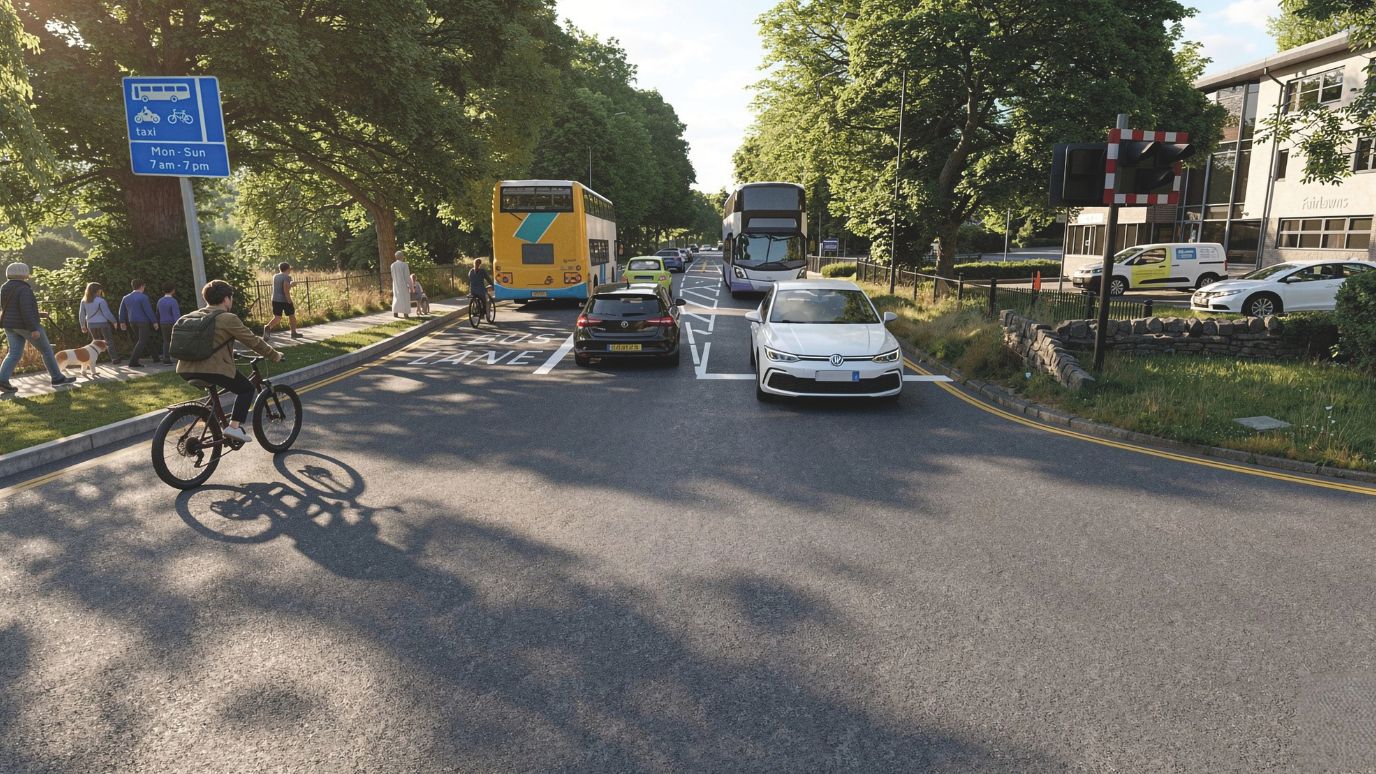
We are proposing measures such as bus lanes, bus gates, traffic signal improvements and other changes that will help buses move through the area more efficiently and reliably.

Safer and easier crossings

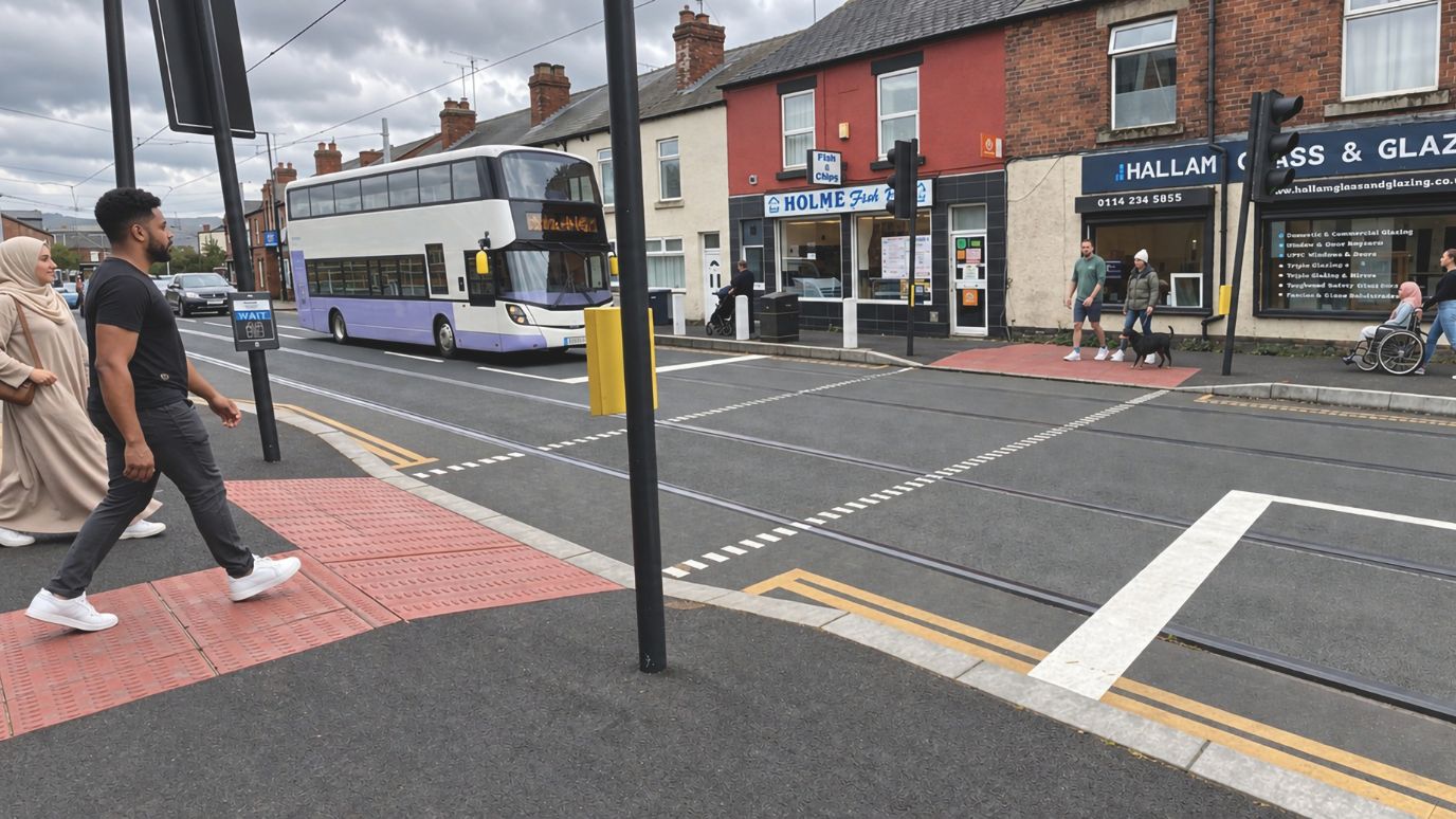
New and upgraded pedestrian crossings will make it easier and safer for people to cross busy roads.

Better bus stops and walking routes

Improvements would include upgraded bus stops, easier access to stops, and improvements to pavements, side roads and junctions to make it easier for people walking and wheeling to get around.

Simpler traffic movements

Changes to turning movements, parking arrangements and traffic management measures to reduce delays and improve safety, while maintaining local access.

Proposed improvements by location

Area-wide improvements

Proposals include upgraded traffic signals to help give buses priority at key junctions, alongside improvements to bus stops, shelters, waiting areas and accessibility features.

Southey Green Road and Halifax Road

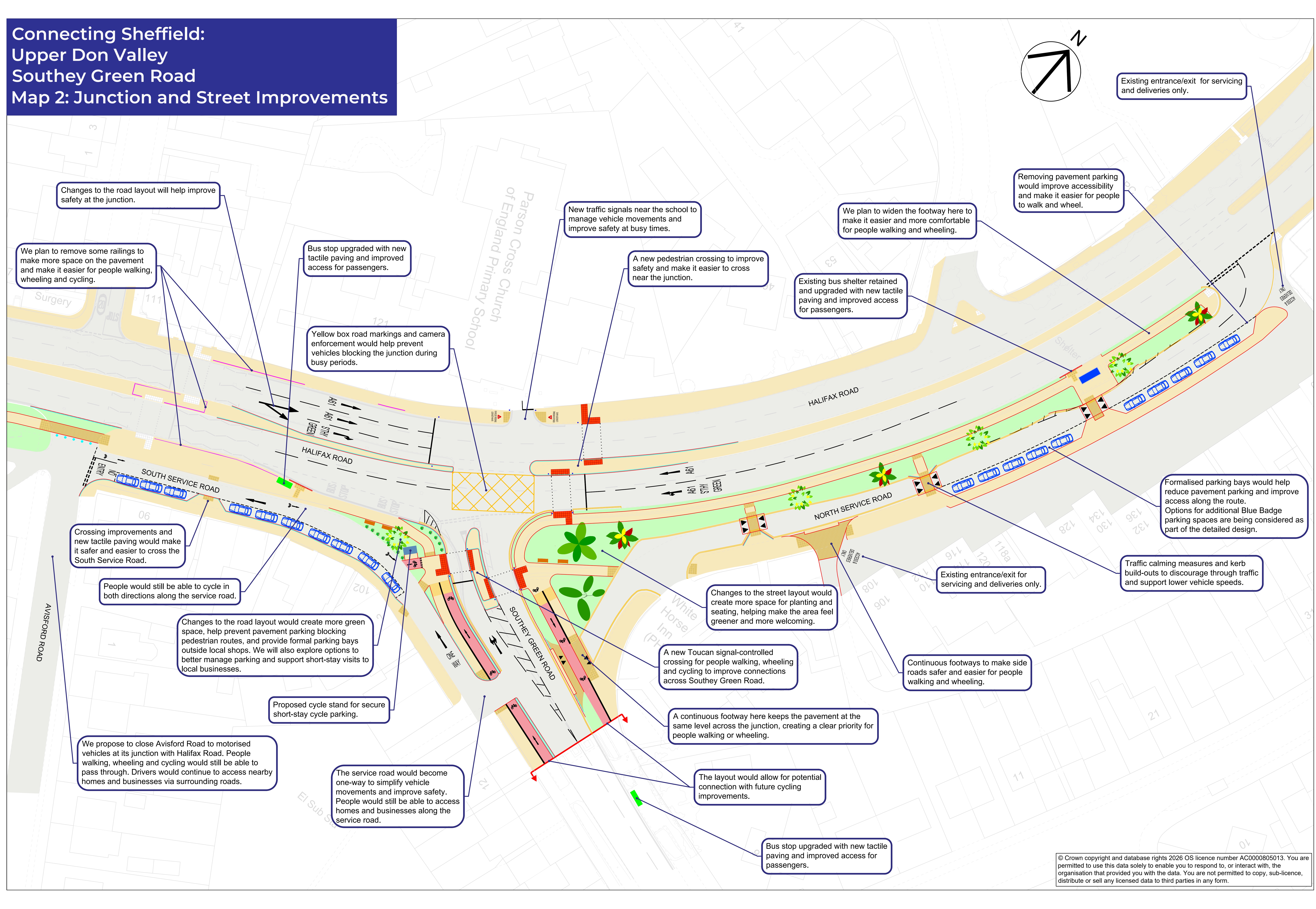
The map below shows the proposals for Southey Green Road and Halifax Road.

You can view a pdf of this map so you can zoom in for more detail.

Map showing proposed improvements at Halifax Road and Southey Green Road, including junction improvements, improved green spaces, improved crossings and changes to parking to improve access to shopsMap of proposals at Southey Green Road and Halifax Road Proposals at Southey Green Road and Halifax Road include:
  • Junction improvements to reduce delays.
  • New and improved crossings near schools, nurseries and shops.
  • Changes to vehicle access arrangements on Avisford Road.
  • Improvements supporting local business access.
  • Formal parking bays and improved pavements.

Fox Hill Road

We are proposing improvements at Fox Hill Road including:

  • New waiting restrictions, including matchdays, to help buses move more easily through the area.
  • Upgraded bus stops.
  • A new pedestrian crossing near Trafalgar Road.

You can view a pdf of proposals at Fox Hill Road here.

Holme Lane

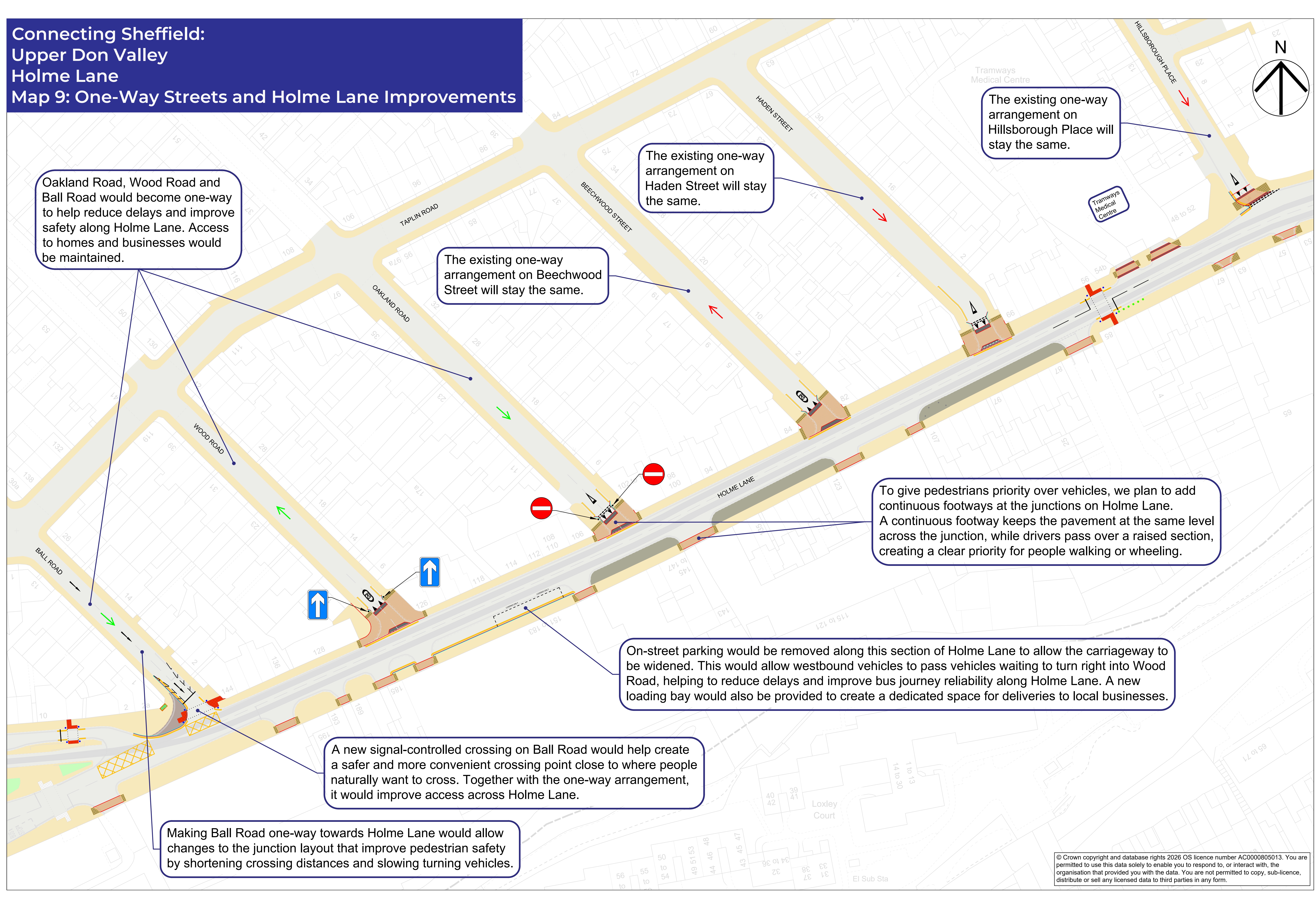
The map below shows the proposals for Holme Lane.

You can view a pdf of this map so you can zoom in for more detail.

Map showing proposals for improvements at Holme Lane including one-way side streets, improved crossings, pedestrian priority and safety and accessibility improvements for people walking and wheelingMap showing proposals for improvements at Holme Lane

Proposals at Holme Lane include:

  • Changes to side street layouts to make things clearer for everyone.
  • New signal-controlled crossings to make it easier and safer to cross the road.
  • Continuous footways across side roads to give priority to pedestrians in line with the Highway Code.
  • Measures to improve safety and accessibility for people walking and wheeling.
  • Changes to the junction layout to reduce delays for everyone.
  • Widening the road which will mean making changes to parking arrangements - this will improve traffic flow and make journeys more reliable.
  • A new loading bay for local businesses.

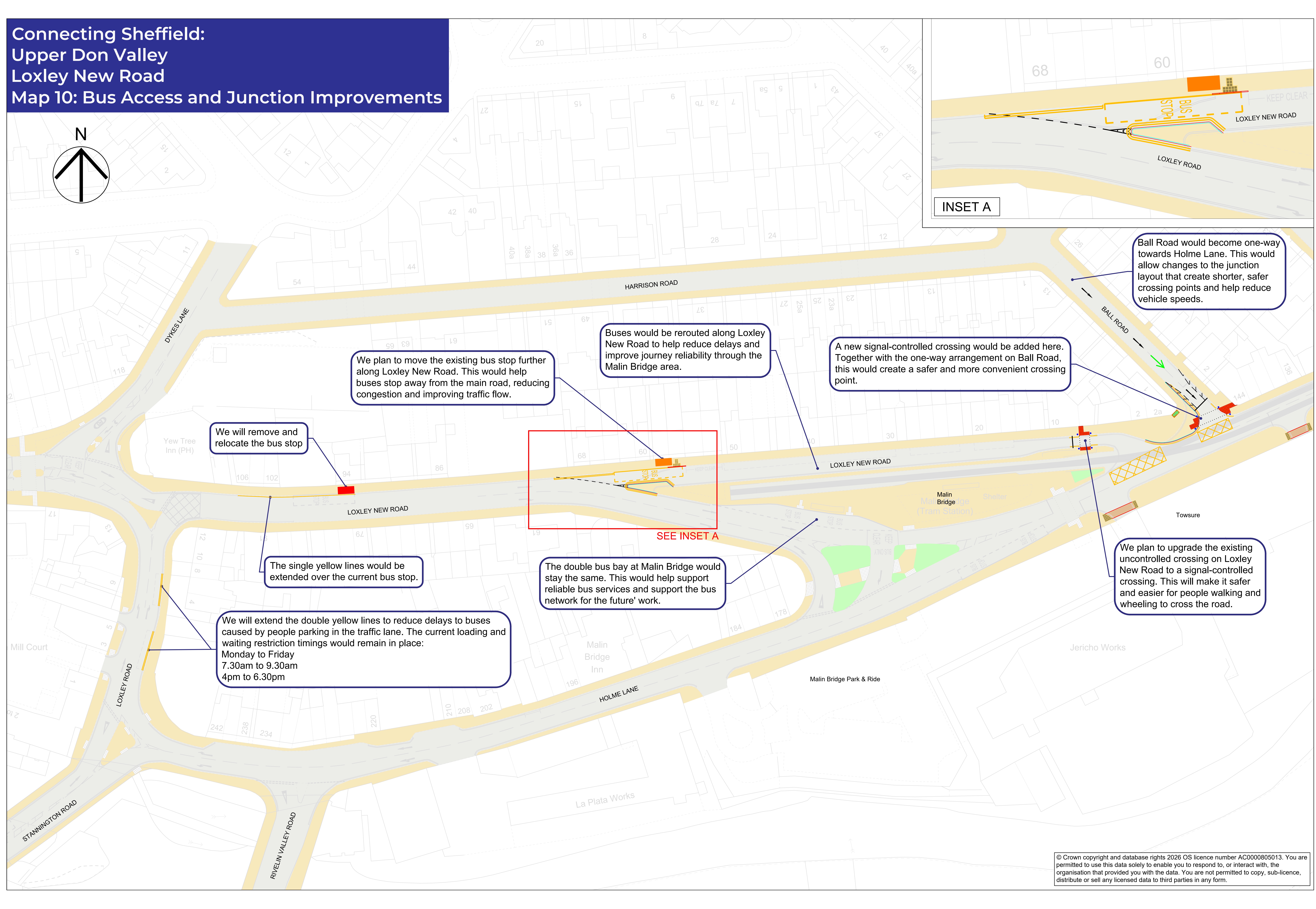
Holme Lane and Loxley New Road

The map below shows the proposals for Holme Lane and Loxley New Road.

You can view a pdf of this map so you can zoom in for more detail.

Map showing proposals for improvements at Holme Lane and Loxley New Road including bus and resident-only access route, improved bus priority and moving a bus stop to imrpove traffic flowMap showing proposals for improvements at Holme Lane and Loxley New Road

Proposals for Holme Lane and Loxley New Road include:

  • A bus and residents-only access route to give buses priority.
  • Bus priority at traffic signals to make bus journeys more reliable.
  • Moving an existing bus stop to improve traffic flow and bus reliability.

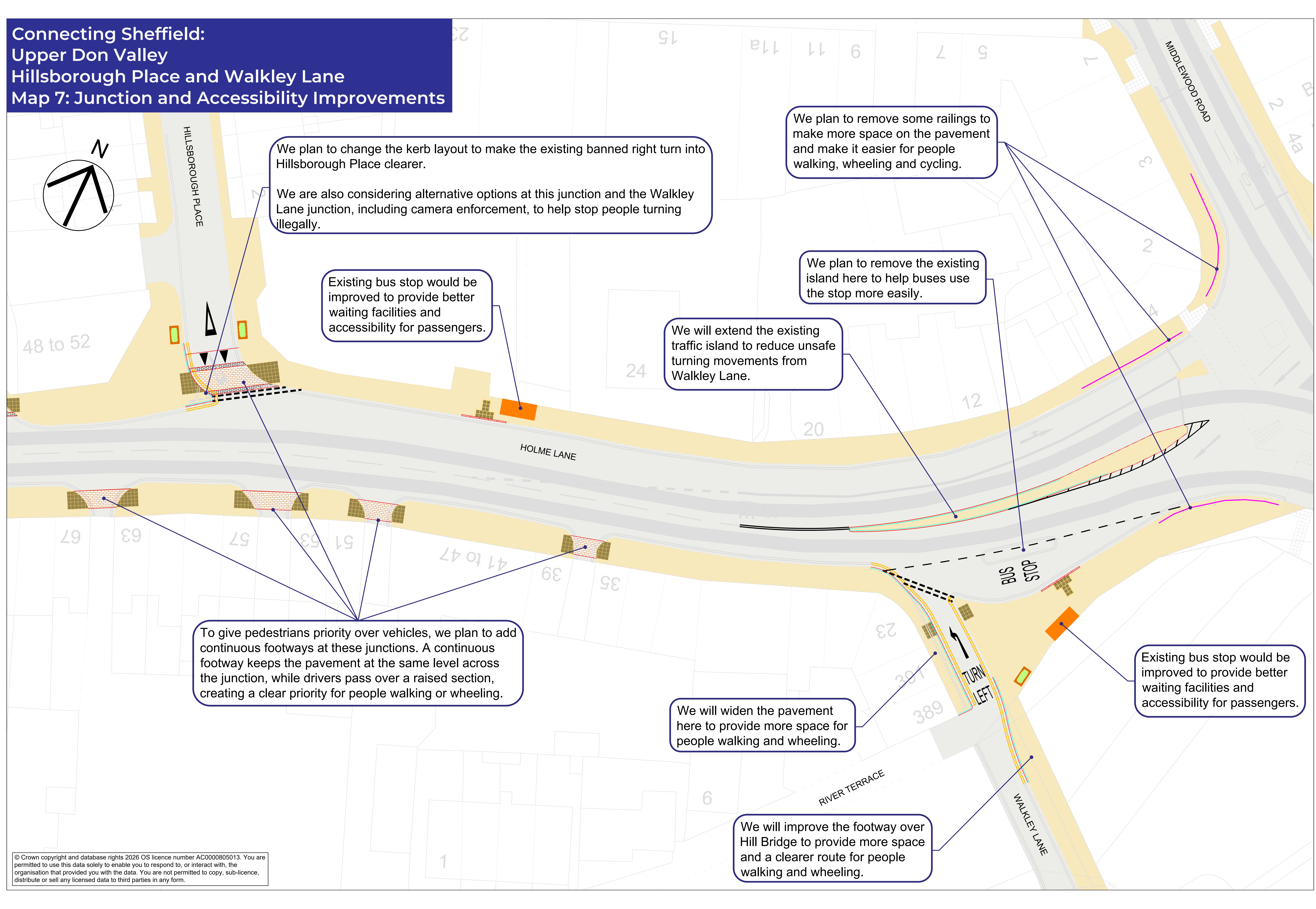
Hillsborough Place and Walkley Lane

The map below shows the proposals for Hillsborough Place and Walkley Lane.

You can view a pdf of this map so you can zoom in for more detail.


Map showing proposed improvements at Hillsborough Place and Walkley Lane, including junction improvements, wider pavements, changes to vehicle turning movements to improve traffic flow and removing railings to improve visibilityMap showing proposed improvements at Hillsborough Place and Walkley Lane

Proposals for Hillsborough Place and Walkley Lane include:

  • Junction improvements to help make bus journeys more reliable.
  • Wider pavements and improved walking routes to make it easier and safer to get around on foot or using a mobility aid.
  • Changes to vehicle turning arrangements to improve traffic flow.
  • Removing existing railings and improving visibility to make the area safer for everyone.

Hillsborough Corner

We are proposing to extend the operating hours of the existing bus and tram gate to make bus and tram journeys more reliable throughout the day.

We propose the bus and tram gate operates from 7am to 7pm, Monday to Saturday.

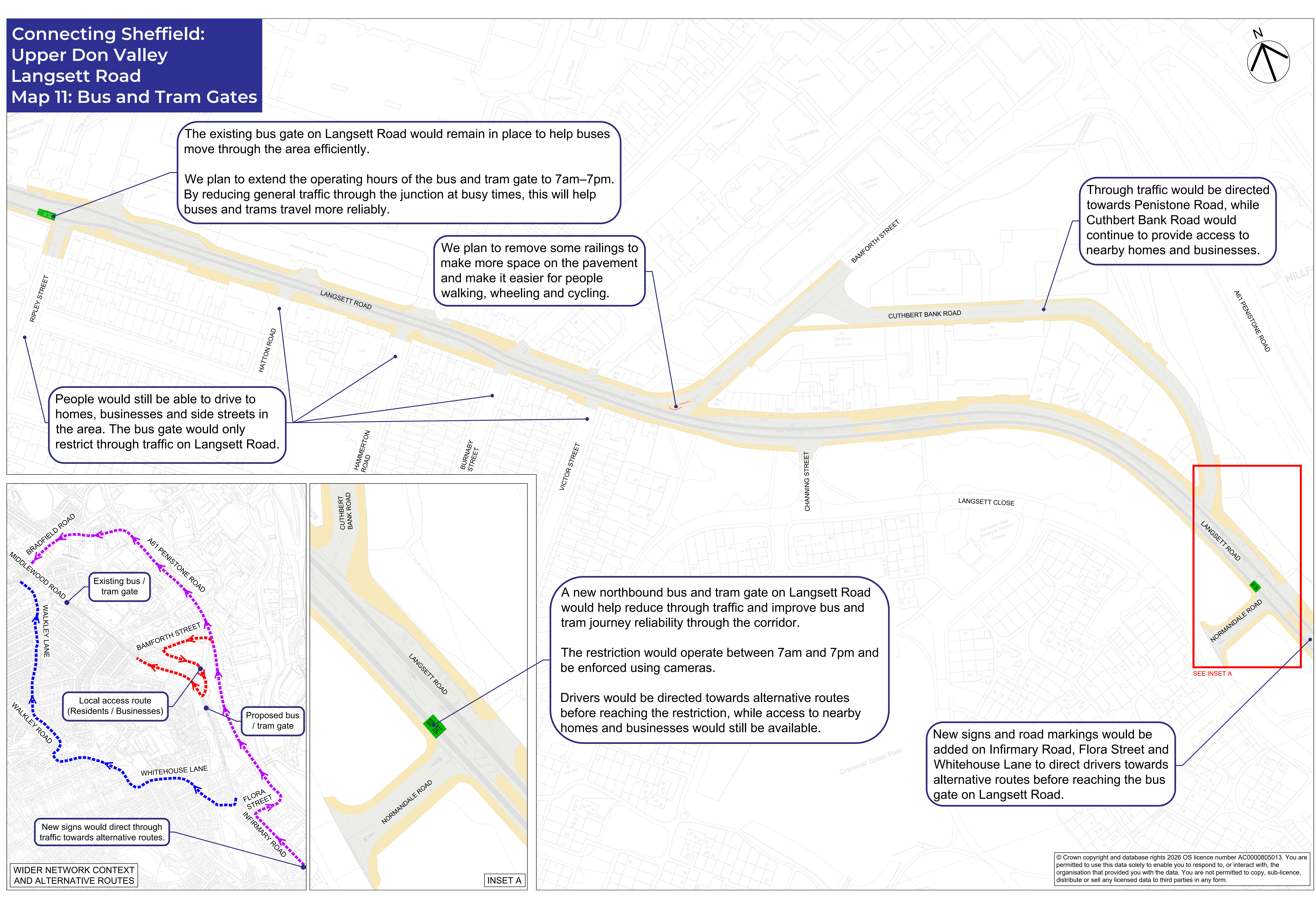
Middlewood Road and Langsett Road

The map below shows the proposals for Middlewood Road and Langsett Road.

You can view a pdf of this map so you can zoom in for more detail.


Map showing proposals for improvements at Middlewood Road and Langsett Road including a new bus and tram gate, continued access for residents and businesses, reduced through-traffic and new signageMap showing proposals for improvements at Middlewood Road and Langsett Road

We are proposing improvements at Middlewood Road and Langsett Road including:

  • A new bus and tram gate on Langsett Road to make journeys by public transport more reliable.
  • Reduced through-traffic to make the area safer and more pleasant for everyone.
  • Continued access for residents and businesses.
  • New signage to help drivers navigate the area.

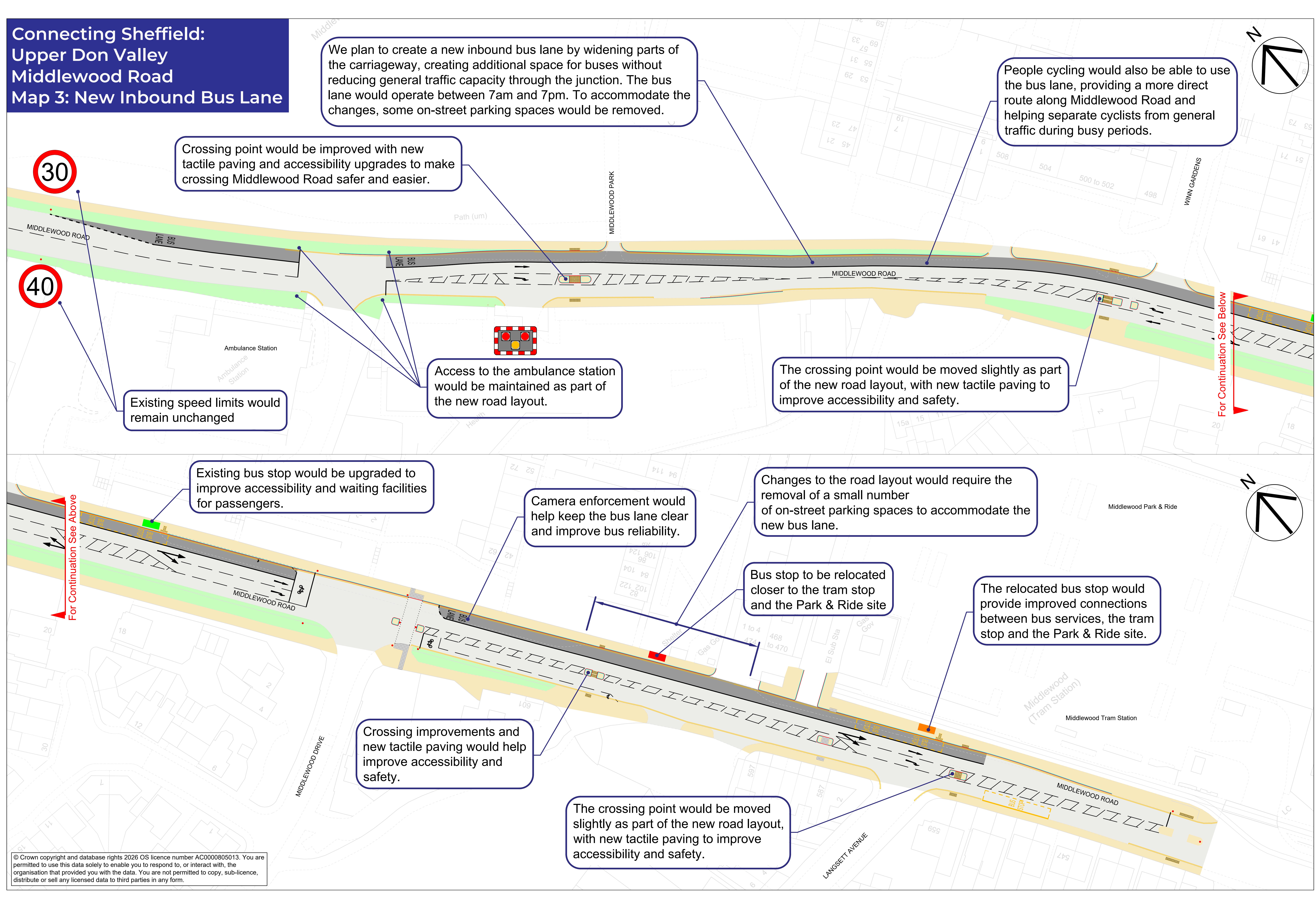
Middlewood Road

The map below shows the proposals for Middlewood Road.

You can view a pdf of this map so you can zoom in for more detail

Map showing proposals for improvement at Middlewood Road including a new inbound bus lane, better access to bus stops and Park & Ride, better crossings and improvements to footwaysMap showing proposals for improvements at Middlewood Road

Proposals for Middlewood Road include:

  • A new inbound bus lane to make bus journeys more reliable.
  • Improved facilities for people cycling.
  • Better access to bus stops and the Park & Ride.
  • Improved pedestrian crossings and refuges to improve safety for everyone.

Leppings Lane and Catch Bar Lane

We are proposing improvements at Leppings Lane and Catch Bar Lane including:

  • New and extended waiting restrictions to help traffic move more smoothly.
  • An extended right-turn lane to improve traffic flow.
  • New and upgraded signal-controlled crossings to make the area safer for everyone.
  • Measures to improve safety around schools, bus stops and key pedestrian routes to make school and other local journeys safer and easier.

You can view a pdf of proposals at Leppings Lane and Catch Bar Lane here.

How can I take part?

There are a number of ways you can share your feedback on the plans. You can:

  • Review the plans, maps and FAQs.
  • Complete the online survey.
  • Contact the project team by email, phone or freepost.
  • Attend one of our public drop-in events.

Public drop-in events

We are holding two public drop-in events where you can come and meet the project team, take a look at our plans and ask any questions you might have about the project. You can also give your feedback to help shape the next stage of design.

Come and join us on:

  • Tuesday 6 October 2026, 2pm to 6pm at Christ Church Hall, Fox Hill Road, Wadsley Bridge, S6 1HB
  • Saturday 10 October 2026, 11.30am to 3.30pm at The Studio, Courtside at Hillsborough, Penistone Road, S6 2DF

Business event

We are also hosting a drop-in event for businesses. Join us on:

  • Thursday 15 October 2026, 8.30am to 10am at The Studio, Courtside at Hillsborough, Penistone Road, S6 2DF

If you would like to come along to our business event, please let us know by emailing us.

What happens next?

Once the consultation closes, we will review all feedback received and consider any changes to the proposals. Following this, the final design will be reviewed by Sheffield City Council before any future construction programme is developed. We will keep you up to date about changes to the project plans as we progress.

Contact us

  • Email: info@connecting-sheffield.co.uk
  • Freephone: 0808 196 5105
  • Freepost: Freepost Connecting SHF

You can also sign up for Sheffield City Council travel and transport email updates.

Have your say on plans to improve bus reliability, safety and accessibility

We're asking for your views on proposed transport improvements across the Upper Don Valley, including Hillsborough, Middlewood, Fox Hill and Southey.

The proposals aim to improve bus journey times and reliability, make streets safer and easier to use, enhance walking and wheeling routes, and improve access to public transport.

The consultation is open from 23 September to 4 November 2026.

Why are we suggesting these improvements?

Hillsborough is one of Sheffield's busiest transport hubs and an important local centre. It connects communities across the Upper Don Valley with the city centre and beyond. Every day, thousands of people travel through the area to get to work, education, healthcare, shops and leisure destinations.

Many local residents rely on bus services for everyday journeys. But congestion, difficult junction layouts and parking issues can cause delays. This can make journeys unreliable and create uncertainty for passengers. Around 30 bus journeys through Hillsborough are delayed each day.

In addition to bus reliability issues, some areas can be difficult to navigate on foot or by wheelchair. There are limited crossing opportunities on busy roads, and facilities are not always as accessible as they could be.

Our proposals aim to address these challenges while maintaining access for residents, businesses and visitors.

What are we trying to achieve?

The project aims to:

  • Improve bus journey times and reliability.
  • Make bus travel a more attractive option.
  • Improve road safety for everyone.
  • Create a better travel experience for older people and families with young children.
  • Make walking and wheeling easier and safer.
  • Make the local area more attractive.

What are we proposing?

The proposals focus on locations where transport and accessibility issues are most commonly experienced. These include:

  • Fox Hill Road
  • Holme Lane
  • Leppings Lane
  • Middlewood Road
  • Langsett Road, and
  • Southey Green Road.

More reliable buses

We are proposing measures such as bus lanes, bus gates, traffic signal improvements and other changes that will help buses move through the area more efficiently and reliably.

Safer and easier crossings

New and upgraded pedestrian crossings will make it easier and safer for people to cross busy roads.

Better bus stops and walking routes

Improvements would include upgraded bus stops, easier access to stops, and improvements to pavements, side roads and junctions to make it easier for people walking and wheeling to get around.

Simpler traffic movements

Changes to turning movements, parking arrangements and traffic management measures to reduce delays and improve safety, while maintaining local access.

Proposed improvements by location

Area-wide improvements

Proposals include upgraded traffic signals to help give buses priority at key junctions, alongside improvements to bus stops, shelters, waiting areas and accessibility features.

Southey Green Road and Halifax Road

The map below shows the proposals for Southey Green Road and Halifax Road.

You can view a pdf of this map so you can zoom in for more detail.

Map showing proposed improvements at Halifax Road and Southey Green Road, including junction improvements, improved green spaces, improved crossings and changes to parking to improve access to shopsMap of proposals at Southey Green Road and Halifax Road Proposals at Southey Green Road and Halifax Road include:
  • Junction improvements to reduce delays.
  • New and improved crossings near schools, nurseries and shops.
  • Changes to vehicle access arrangements on Avisford Road.
  • Improvements supporting local business access.
  • Formal parking bays and improved pavements.

Fox Hill Road

We are proposing improvements at Fox Hill Road including:

  • New waiting restrictions, including matchdays, to help buses move more easily through the area.
  • Upgraded bus stops.
  • A new pedestrian crossing near Trafalgar Road.

You can view a pdf of proposals at Fox Hill Road here.

Holme Lane

The map below shows the proposals for Holme Lane.

You can view a pdf of this map so you can zoom in for more detail.

Map showing proposals for improvements at Holme Lane including one-way side streets, improved crossings, pedestrian priority and safety and accessibility improvements for people walking and wheelingMap showing proposals for improvements at Holme Lane

Proposals at Holme Lane include:

  • Changes to side street layouts to make things clearer for everyone.
  • New signal-controlled crossings to make it easier and safer to cross the road.
  • Continuous footways across side roads to give priority to pedestrians in line with the Highway Code.
  • Measures to improve safety and accessibility for people walking and wheeling.
  • Changes to the junction layout to reduce delays for everyone.
  • Widening the road which will mean making changes to parking arrangements - this will improve traffic flow and make journeys more reliable.
  • A new loading bay for local businesses.

Holme Lane and Loxley New Road

The map below shows the proposals for Holme Lane and Loxley New Road.

You can view a pdf of this map so you can zoom in for more detail.

Map showing proposals for improvements at Holme Lane and Loxley New Road including bus and resident-only access route, improved bus priority and moving a bus stop to imrpove traffic flowMap showing proposals for improvements at Holme Lane and Loxley New Road

Proposals for Holme Lane and Loxley New Road include:

  • A bus and residents-only access route to give buses priority.
  • Bus priority at traffic signals to make bus journeys more reliable.
  • Moving an existing bus stop to improve traffic flow and bus reliability.

Hillsborough Place and Walkley Lane

The map below shows the proposals for Hillsborough Place and Walkley Lane.

You can view a pdf of this map so you can zoom in for more detail.


Map showing proposed improvements at Hillsborough Place and Walkley Lane, including junction improvements, wider pavements, changes to vehicle turning movements to improve traffic flow and removing railings to improve visibilityMap showing proposed improvements at Hillsborough Place and Walkley Lane

Proposals for Hillsborough Place and Walkley Lane include:

  • Junction improvements to help make bus journeys more reliable.
  • Wider pavements and improved walking routes to make it easier and safer to get around on foot or using a mobility aid.
  • Changes to vehicle turning arrangements to improve traffic flow.
  • Removing existing railings and improving visibility to make the area safer for everyone.

Hillsborough Corner

We are proposing to extend the operating hours of the existing bus and tram gate to make bus and tram journeys more reliable throughout the day.

We propose the bus and tram gate operates from 7am to 7pm, Monday to Saturday.

Middlewood Road and Langsett Road

The map below shows the proposals for Middlewood Road and Langsett Road.

You can view a pdf of this map so you can zoom in for more detail.


Map showing proposals for improvements at Middlewood Road and Langsett Road including a new bus and tram gate, continued access for residents and businesses, reduced through-traffic and new signageMap showing proposals for improvements at Middlewood Road and Langsett Road

We are proposing improvements at Middlewood Road and Langsett Road including:

  • A new bus and tram gate on Langsett Road to make journeys by public transport more reliable.
  • Reduced through-traffic to make the area safer and more pleasant for everyone.
  • Continued access for residents and businesses.
  • New signage to help drivers navigate the area.

Middlewood Road

The map below shows the proposals for Middlewood Road.

You can view a pdf of this map so you can zoom in for more detail

Map showing proposals for improvement at Middlewood Road including a new inbound bus lane, better access to bus stops and Park & Ride, better crossings and improvements to footwaysMap showing proposals for improvements at Middlewood Road

Proposals for Middlewood Road include:

  • A new inbound bus lane to make bus journeys more reliable.
  • Improved facilities for people cycling.
  • Better access to bus stops and the Park & Ride.
  • Improved pedestrian crossings and refuges to improve safety for everyone.

Leppings Lane and Catch Bar Lane

We are proposing improvements at Leppings Lane and Catch Bar Lane including:

  • New and extended waiting restrictions to help traffic move more smoothly.
  • An extended right-turn lane to improve traffic flow.
  • New and upgraded signal-controlled crossings to make the area safer for everyone.
  • Measures to improve safety around schools, bus stops and key pedestrian routes to make school and other local journeys safer and easier.

You can view a pdf of proposals at Leppings Lane and Catch Bar Lane here.

How can I take part?

There are a number of ways you can share your feedback on the plans. You can:

  • Review the plans, maps and FAQs.
  • Complete the online survey.
  • Contact the project team by email, phone or freepost.
  • Attend one of our public drop-in events.

Public drop-in events

We are holding two public drop-in events where you can come and meet the project team, take a look at our plans and ask any questions you might have about the project. You can also give your feedback to help shape the next stage of design.

Come and join us on:

  • Tuesday 6 October 2026, 2pm to 6pm at Christ Church Hall, Fox Hill Road, Wadsley Bridge, S6 1HB
  • Saturday 10 October 2026, 11.30am to 3.30pm at The Studio, Courtside at Hillsborough, Penistone Road, S6 2DF

Business event

We are also hosting a drop-in event for businesses. Join us on:

  • Thursday 15 October 2026, 8.30am to 10am at The Studio, Courtside at Hillsborough, Penistone Road, S6 2DF

If you would like to come along to our business event, please let us know by emailing us.

What happens next?

Once the consultation closes, we will review all feedback received and consider any changes to the proposals. Following this, the final design will be reviewed by Sheffield City Council before any future construction programme is developed. We will keep you up to date about changes to the project plans as we progress.

Contact us

  • Email: info@connecting-sheffield.co.uk
  • Freephone: 0808 196 5105
  • Freepost: Freepost Connecting SHF

You can also sign up for Sheffield City Council travel and transport email updates.

  • The Connecting Sheffield: Upper Don Valley project focuses on making journeys by bus more reliable, while also improving road safety and making local journeys easier for people who are walking, wheeling and cycling.
    Our proposals cover changes along key routes in:

    • Southey / Fox Hill / Birley Carr – Southey Green Road, Halifax Road and Fox Hill Road
    • Middlewood – Middlewood Road, Catch Bar Lane and Leppings Lane
    • Hillsborough – Holme Lane, Loxley New Road, Hillsborough Corner and Langsett Road

    We will make sure people can still access the area by car, while improving public transport and making it easier to walk or use a wheelchair or mobility aid around the area. 

    The main focus of the proposals is on reducing delays to bus journeys at key locations and giving buses more priority. This includes things like:

    • bus lanes, bus gates and changes to traffic signals to give buses priority
    • changes to junctions, turning movements, waiting restrictions and parking to help keep routes clear 
    • upgraded bus stops, including improved accessibility, to make the experience better for passengers

    The proposals will also make journeys safer and easier for people walking and wheeling by delivering:

    • new and improved crossings
    • safer junctions and side roads
    • improved pavements

    Together, these changes will enable faster and more reliable bus journeys, improve people’s confidence in public transport, and make local travel safer and more accessible. The proposals are particularly important for people who rely on buses, as well as helping older people, parents with young children, disabled people and people with mobility needs to get around the area.

    We want to hear your views on the proposals. Your feedback will help shape the final plans and make sure they work as well as possible for the people who use these routes every day.

    Before responding to this survey, we recommend that you review the plans in the 'Documents' section on the main page, which provide more information on what we are planning

    You can answer as many or as few questions as you like. The length of time the survey will take will vary, depending on how many sections you choose to answer and how much detail you would like to give.

    This survey closes at 11.59pm on Wednesday 4 November 2026.

    Take Survey
Page last updated: 25 Sep 2026, 01:09 PM