Connecting Sheffield: Magna - Tinsley

Share Connecting Sheffield: Magna - Tinsley on Facebook Share Connecting Sheffield: Magna - Tinsley on Twitter Share Connecting Sheffield: Magna - Tinsley on Linkedin Email Connecting Sheffield: Magna - Tinsley link
A blue illustration of the Meadowhall dome, with a person on a bike in red and text that reads 'Magna - Tinsley'

Connecting Sheffield: Magna-Tinsley is designed to deliver improvements to walking and cycling infrastructure and to provide better connections to public transport links to make it easier for people to travel around and between Magna, Tinsley and Meadowhall by walking, wheeling, cycling and using public transport.

These changes will increase access to leisure and employment opportunities at Meadowhall and in Rotherham and Sheffield for Tinsley residents.

By providing improved walking and cycling routes, these proposals will make walking and cycling for shorter journeys a more attractive and accessible option as well as improving travel choices for people without access to a car.

A key aim is to reduce people's reliance on car travel for shorter trips. This will keep roads clearer for public transport and people who have to travel by car, and help improve air quality around Magna, Tinsley and Meadowhall.

What's next?

We will shortly advertise the Traffic Regulation Orders (TROs) required for the scheme. A TRO is a legal order which allows councils to change the way roads are used, such as regulating the speed limit, banning or enabling turns, making a road one-way or changing loading and waiting restrictions – often indicated by parking bays or yellow lines.

Once we have advertised the order, there is a 28-day formal objection period. We must consider all objections before we can make a TRO operational.

We will let you know when the TROs are advertised and how to provide formal feedback.

In the meantime, we’ve included the plans for the TROs below. If you have any questions, comments or concerns, you can let us know by emailing us via connectingsheffield@sheffield.gov.uk

Sheffield Road TRO

We’re proposing to extend the existing 24-hour main carriageway clearway to the Rotherham boundary, which will include no stopping on footways to improve traffic flow and continuity for the cycle route.


Image shows the technical drawing for the Traffic Regukation Order on Sheffield Road to extend the existing 24-hour main carriageway clearway to the Rotherham boundary. Sheffield Road Traffic Regulation Order plan


Ferrars Road TRO


Vehicles travelling onto Sheffield Road from Ferrars Road will only be able to turn left – they won’t be able to u-turn or turn right, which will reduce potential collisions from the new right turn from Sheffield Road into Ferrars Road. Removing an existing ahead only restriction by St Lawrence Road means vehicles leaving Ferrars Road will now be able to turn right towards Meadowhall, and head back towards Rotherham via the junction with Blackburn Meadows Way.


Image shows the technical drawing for the Ferrars Road Traffic Regulation Order, which proposes that vehicles travelling onto Sheffiled Road from Ferrars Road will only be able to turn left. They won't be able to u-turn or turn right. They will be able to turn right further along the road by St Lawrence Road as we propose to remove an existing ahead only restriction in this area.


Sheffield Road / Blackburn Meadows Way TRO

New one way traffic restrictions to manage vehicle movements, helping to avoid potential collisions.


Image shows the technical drawing for the Sheffield Road / Blackburn Meadows Way Traffic Regulation Order, which proposes new one way restrictions along Sheffield Road towards Sheffield, and on Sheffield Road towards Rotherham and Meadowhall, at the junction with Blackburn Meadows Way. Traffic will also be able to turn right into St Lawrence Road. Sheffield Road / Blackburn Meadows Way Traffic Regulation Order plan


  • Latest updates - April 2024

    Share Latest updates - April 2024 on Facebook Share Latest updates - April 2024 on Twitter Share Latest updates - April 2024 on Linkedin Email Latest updates - April 2024 link
    supporting image

    Work is due to start on the Connecting Sheffield: Magna – Tinsley project. Our contractor, Amey, will start from Thursday 18 April 2024 to build a new crossing for pedestrians and cyclists on Sheffield Road by the junction with Raby Street.

    During construction, we’ll need to install temporary traffic lights to operate on Sheffield Road on either side of the junction with Raby Street. There will also be no access to and from Raby Street from Sheffield Road during the works to allow space for the work to safely happen. We will have the following diversions from Raby Street in place:

    • To and from M1 Junction 34 South: via Bawtry Road and Norborough Road
    • To and from Rotherham (Sheffield Road): via St Lawrence Road

    You can see the diversion routes on the map below.

    A map showing Sheffield Road and Raby Street with diversion routes marked at Norobrough Road and St Lawrence Road. A red cross marks where the Raby Street junction is closed. Text reads 'No access to / from Raby Street to Sheffield Road'.


    We expect the works to take around three months, and we’ll work to get access restored as soon as we can.

    If you’d like more information on the construction work you can email us via connectingsheffield@sheffield.gov.uk

  • Update - December 2023 - updated proposals

    Share Update - December 2023 - updated proposals on Facebook Share Update - December 2023 - updated proposals on Twitter Share Update - December 2023 - updated proposals on Linkedin Email Update - December 2023 - updated proposals link
    supporting image

    A map of the Magna Tinsley scheme area in Sheffield, with the letters A, B C, D E and F marked to show the areas where works will take placeMap of the Connecting Sheffield: Magna - Tinsley project area

    Meadowhall Road Crossing

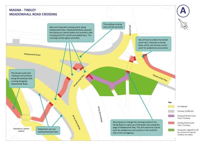
    We plan to relocate the proposed Meadowhall Road crossing point near Alsing Road to go via the existing crossing point between Meadowhall Road and Meadowhall Way.

    We are exploring ways to overcome the existing pinchpoint for pedestrians and cyclists on the approach to Alsing Road from Meadowhall Way over the River Don.

    Map of Meadowhall Road shoing the scheme works. With annotations that say: New and improved crossing points along Meadowhall Way / Meadowhall Road opposite the Sainsbury’s petrol station will provide a safe crossing point for cyclists and pedestrians and thes crossings will be signal controlled. The existing crossing over Meadowhall Road towards Alsing Road will be removed. We will look to widen the shared cycle track / footway by Alsing Road, which will remove a pinch point for pedestrians and cyclists. We propose to change the crossing location from Alsing Road to make use of the green area along the edge of Meadowhall Way. This will overcome a pinch point for pedestrians and cyclists on the northern side of the carriageway.Pedestrians can use existing footways along Meadowhall Road.The shared cycle track / footway will continue along the existing route alongside Meadowhall Road.Our proposals for the Meadowhall Road crossing

    Meadowhall Way to Blackburn Meadows Way

    We plan to further separate pedestrians and cyclists along Blackburn Meadows Way to provide more dedicated spaces for cycling, walking and wheeling.

    Pedestrians will be able to walk on the pavement on the Meadowhall to Tinsley side of the road, but there will be a shared use section for walking, wheeling and cycling from the crossing under Tinsley viaduct to access the Canal Cycleway link.

    Map of the scheme area at Blackburn Meadows Way and Meadowhall Way, with annotations: We will maintain the traffic signals before the tramlines at Blackburn Meadows Way, and add a signal for pedestrians and cyclists to use on both sides. The shared cycle track / footway will run along the northern side of Blackburn Meadows Way, from the crossing as far as the Canal Cycleway Link, after which the northern side will continue as a footway only. We will maintain existing access ways for the cycle track opposite the Canal Cycleway Link on Blackburn Meadows Way. We will change a section of the existing path into a two-way segregated cycle track, separating cyclists and pedestrians on either side of Blackburn Meadows Way. We will establish a two-way cycle track on the south side of Blackburn Meadows Way. We will use the existing signalcontrolled crossing for pedestrians and cyclists at the junction of Blackburn Meadows Way and Meadowhall Way.Map of the project area at Meadowhall Way and Blackburn Meadows Way

    Blackburn Meadows Way, Meadowhall to Rotherham

    We will introduce a segregated cycle route on the Tinsley to Meadowhall side of Blackburn Meadows Way.

    We propose a shared use section for walking, cycling and wheeling, between Sheffield Road and the Blackburn Meadows Way Meadowhall-bound bus stop.


    Map of the scheme area at Blackburn Meadows Way, showing the proposed cycle track. With annotation: There will now be a two-way segregated cycle track on the south side of Blackburn Meadows Way. The footway on the north side will stay as it is to separate pedestrians and cyclists along the majority of the length of Blackburn Meadows Way.Map of the project area at Blackburn Meadows Way, showing the proposed cycle route

    Blackburn Meadows Way to Sheffield Road

    We plan to reduce the width of the Blackburn Meadows Way two-way cycle route on the approach to Meadowhall Way from 4m to 3m, so we can keep two lanes for road traffic approaching Meadowhall Way.

    We plan to reduce the number of vehicle lanes on Sheffield Road, heading towards Rotherham, from two to one at the junction with Blackburn Meadows Way. This will help to remove a safety concern around vehicles having to quickly merge after the junction.


    Map of the scheme at Blackburn Meadows Way to Sheffield Road. With annotations: We will change a section of the existing path on the Tinsley to Meadowhall side of Blackburn Meadows Way to segregate pedestrians and cyclists. The footway will be for pedestrian use only and we will provide a separate crossing for pedestrians and a new crossing for cyclists on Sheffield Road just after Ferrars Road as you travel from Sheffield to Rotherham. We will improve access into Tinsley village on Ferrars Road. The access road between Ferrars Road and St Lawrence Road will be closed. A new access route with a dropped kerb will be added from Sheffield Road, and we'll use the existing path for pedestrians. We will improve access into Tinsley village on St Lawrence Road. We will reduce the number of lanes on Sheffield Road on the approach to, and the road after, the junction with Blackburn Meadows Way, from two to one. This will remove a safety concern around vehicles merging shortly after the junction. It will also allow us to create a new right-turn vehicle lane into Ferrars Road, removing another safety concern about vehicles u-turning on Sheffield Road. We will provide a segregated cycle track and footway on Blackburn Meadows Way, up to the Meadowhall-bound bus stop. The cycle track will bypass the bus stop and continue along Blackburn Meadows Way. We may also need to widen the footway to create more space around the bus shelter. Map of the project area at Blackburn Meadows Way to Sheffield Road


    Sheffield Road

    We plan to further separate pedestrians and cyclists from vehicles and each other along Sheffield Road to provide more dedicated spaces for cycling, walking and wheeling with one-way cycle routes to directly connect into the scheme being delivered on Sheffield Road in Rotherham.

    We propose continuous pavements and cycle routes across business access points on Sheffield Road where appropriate to give pedestrians and cyclists priority over turning vehicles.

    We propose to Introduce the ability to turn right into Tinsley Village from Sheffield Road to improve access into Tinsley. This will help to remove a safety concern of vehicles U-turning on Sheffield Road.


    Map of the scheme at Sheffield Road. With annotations: We will change sections of the existing path to segregate pedestrians and cyclists. We'll also separate the cycle track from the road with a kerb. We will provide segregated cycle tracks across business access points, giving cyclists priority over turning vehicles. We will remove the uncontrolled crossing point that is currently in place just before the Deadman's Hole Lane junction as you travel from Sheffield to Rotherham. We will need to remove a small number of parking bays on a section of Sheffield Road, close to the Magna Science and Adventure Centre and on the opposite side of the road, to create space for the new high-quality segregated cycle route. We will move the existing bus shelter forward on the opposite side of the Road to Magna, so that the cycle track and footway can continuously run behind it. At the Sheffield / Rotherham boundary, this scheme will link into a complementary scheme being delivered by Rotherham Metropolitan Borough Council which will improve cycling connections between Sheffield and Rotherham.Map of the project at Sheffield Road


    Raby Street intersection


    Map of the scheme at the Raby Street intersection. With annotations: Roadside parking will remain unaffected at either side of the Raby Street junction with Sheffield Road. Cyclists will use existing dropped kerbs either side of the two-way Raby Street to help them join or exit the carriageway. Roadside parking on Raby Street will remain unaffected. We'll install a new and improved signal-controlled crossing that will stop traffic and give priority to pedestrians and cyclists. Map of the project at the Raby Street intersection


Page last updated: 05 Sep 2024, 03:07 PM